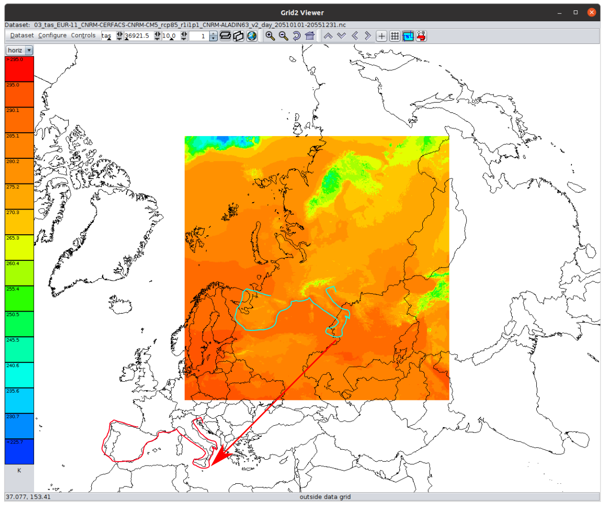
Forgot to send this to mail list. BTW, I prefer the github issues on the
relevant repository, which keeps everything public.

---------- Forwarded message ---------
From: John Caron <jcaron1129@xxxxxxxxx>
Date: Tue, Jun 28, 2022 at 6:16 PM
Subject: Re: [netcdf-java] cordex rotatedpole help
To: andrea antonello <andrea.antonello@xxxxxxxxx>


it looks like they forgot to add false_easting and false_northing
parameters.


If I use the following ncml to add those:

<?xml version="1.0" encoding="UTF-8"?>
<netcdf xmlns="http://www.unidata.ucar.edu/namespaces/netcdf/ncml-2.2";

location="03_tas_EUR-11_CNRM-CERFACS-CNRM-CM5_rcp85_r1i1p1_CNRM-ALADIN63_v2_day_20510101-20551231.nc">

<variable name="Lambert_Conformal" >
  <attribute name="false_easting" type="float" value="2800" />
  <attribute name="false_northing" type="float" value="2800" />
</variable>

</netcdf>

i get the attached image


On Tue, Jun 28, 2022 at 3:10 PM andrea antonello <andrea.antonello@xxxxxxxxx>
wrote:

> Hi John,
> thanks for your reply.
>
> Attached is what i see
>> for
>> 03_tas_EUR-11_CNRM-CERFACS-CNRM-CM5_rcp85_r1i1p1_CNRM-ALADIN63_v2_day_20510101-20551231.nc.
>> the lower left is (0,0) at 50N, 10E, which is what id expect for
>>
>>     LambertConformal{earth_radius=6371.229, par1=49.5, par2=49.5,
>> falseEasting=0.0, falseNorthing=0.0, lon0Degrees=10.5}}
>>
>> For this and/or the rotated pole problems, do you know what it should
>> look like, for example, what the lat/lon corners of the grid are supposed
>> to be? I might be able to reverse engineer that.
>>
>
> For the LambertConformal I haven't yet found a way to fix it or any tool
> that would display the data properly. As you can see in your modified
> image, there is quite some shift:
>
> [image: lambertconformal_shift.png]
> But I will try to find a way to define the coordinates and send them in.
>
> Instead, regarding
> the
> 02_tas_AFR-22_CCCma-CanESM2_rcp85_r1i1p1_CCCma-CanRCM4_r2_day_20510101-20551231.nc
> rotated pole, this is what I read with the libs:
>
> Proj X Axis (rlon): -24.75 -> 60.3900146484375   (388)  extent:
> 85.1400146484375
> Proj Y Axis (rlat): -45.869998931884766 -> 42.35000228881836   (402)
>  extent: 88.22000122070312
> Time Axis (time): 2051-01-01T12:00:00Z -> 2055-12-31T12:00:00Z   (1825)
> Longitude: -179.88999938964847 -> 179.8900146484375  extent:
> 359.78001403808594
> Latitude: -45.869998931884766 -> 42.35000228881836  extent:
> 88.22000122070312
>
> resulting in:
> [image: image.png]
>
> while the right extents are these:
>
> Longitude: -24.75 -> 60.390014648437486  extent: 85.14001464843749
> Latitude: -45.869998931884766 -> 42.35000228881836  extent:
> 88.22000122070312
>
> [image: image.png]
>
> Thank you,
> cheers,
> Andrea
>
>
>
>
>
>
>>
>> regards, John
>>
>> On Mon, Jun 27, 2022 at 3:31 AM andrea antonello <
>> andrea.antonello@xxxxxxxxx> wrote:
>>
>>> Hi, a short update on my findings.
>>>
>>> Martin, I do not think my problem is the one you are investigating. I
>>> noticed that in the case 02 (Africa) of the linked datasets there is a
>>> shift by 180 degrees.
>>> Setting the longitude properly turns into proper results. But I didn't
>>> yet find a way to understand when that is the case. If anyone with
>>> experience could identify the reason, that would be great.
>>>
>>> Now I also found another meteo dataset in LambertConformal that also
>>> doesn't behave right. Since also Panolpy and ncWMS do not place the dataset
>>> properly (it is shifted, scaled and rotated), I assume it is again
>>> something with the dataset, else the projToLatLon should calculate the
>>> result properly. Maybe a gentle soul can see something I do not in the
>>> dataset's metadata: https://we.tl/t-ui4CZmQ0pS
>>>
>>> Cheers,
>>> Andrea
>>>
>>>
>>>
>>>
>>> On Wed, Jun 22, 2022 at 8:12 AM andrea antonello <
>>> andrea.antonello@xxxxxxxxx> wrote:
>>>
>>>> Hallo Martin,
>>>> nice to hear from you :-)
>>>>
>>>>> I did an analysis of "Rotated Pole" implementations in UCAR library
>>>>> and PROJ a few months ago for trying to reverse engineering their
>>>>> mathematical definitions. It was an attempt (still in progress) to get a
>>>>> formal definition of this operation method in a way similar than what EPSG
>>>>> does. My current understanding of the situation is documented there:
>>>>>
>>>>>
>>>>> https://github.com/opengeospatial/MetOceanDWG/blob/main/MetOceanDWG%20Projects/Authority%20Codes%20for%20CRS/Pole%20rotation.md
>>>>>
>>>>> In summary, while CF-convention cites only one pole rotation method
>>>>> (namely "rotated_latitude_longitude"), the UCAR netCDF library has
>>>>> two implementations: the above cited one and "rotated_latlon_grib".
>>>>> The source code of those two implementations look totally different, but
>>>>> they are really the same thing computed in different ways. The major
>>>>> difference is that "rotated_latitude_longitude" rotates the *North*
>>>>> pole while "rotated_latlon_grib" rotates the *South* pole. Rotating
>>>>> the wrong pole causes an error of 180° in longitude and 90° - φ (or
>>>>> something like that, I do not remember exactly) in latitude, which looks
>>>>> like what you are observing with Africa. The method defined by
>>>>> CF-Convention rotates the North pole, while the method defined by World
>>>>> Meteorological Organization (WMO) used in GRIB files rotates the South
>>>>> pole.
>>>>>
>>>>> Note: looking at the math, it appears that we do not need two distinct
>>>>> implementations for the North pole and South pole cases. We can use the
>>>>> South pole rotation (the one defined by WMO) as the fundamental
>>>>> definition,
>>>>> and express the Norh pole case (the one defined by CF-Conventions) with a
>>>>> transformation applied on the input parameters before to delegate to the
>>>>> formulas of the South pole case. The above link gives examples for testing
>>>>> the same coordinate operations with UCAR, PROJ and Apache SIS libraries.
>>>>>
>>>> that is interesting. You think that is the reason? From the findings in
>>>> the mentioned ncWMS issue, it seems that renaming some variables can lead
>>>> to proper results (with ncWMS), but when I do that, I am not even able to
>>>> properly handle the projection object (which changes in that case, need to
>>>> investigate more).
>>>> Did you find a  solution to tweak this projection issue using just the
>>>> netcdf-java libraries?
>>>>
>>>> Thank you,
>>>> Andrea
>>>>
>>>>
>>>>
>>>>
>>>>
>>>>
>>>>>     Martin
>>>>>
>>>>>
>>>>> _______________________________________________
>>>>> NOTE: All exchanges posted to Unidata maintained email lists are
>>>>> recorded in the Unidata inquiry tracking system and made publicly
>>>>> available through the web.  Users who post to any of the lists we
>>>>> maintain are reminded to remove any personal information that they
>>>>> do not want to be made public.
>>>>>
>>>>>
>>>>> netcdf-java mailing list
>>>>> netcdf-java@xxxxxxxxxxxxxxxx
>>>>> For list information or to unsubscribe, visit:
>>>>> https://www.unidata.ucar.edu/mailing_lists/
>>>>>
>>>> _______________________________________________
>>> NOTE: All exchanges posted to Unidata maintained email lists are
>>> recorded in the Unidata inquiry tracking system and made publicly
>>> available through the web.  Users who post to any of the lists we
>>> maintain are reminded to remove any personal information that they
>>> do not want to be made public.
>>>
>>>
>>> netcdf-java mailing list
>>> netcdf-java@xxxxxxxxxxxxxxxx
>>> For list information or to unsubscribe, visit:
>>> https://www.unidata.ucar.edu/mailing_lists/
>>>
>> _______________________________________________
> NOTE: All exchanges posted to Unidata maintained email lists are
> recorded in the Unidata inquiry tracking system and made publicly
> available through the web.  Users who post to any of the lists we
> maintain are reminded to remove any personal information that they
> do not want to be made public.
>
>
> netcdf-java mailing list
> netcdf-java@xxxxxxxxxxxxxxxx
> For list information or to unsubscribe, visit:
> https://www.unidata.ucar.edu/mailing_lists/
>
Attachment:
Screenshot from 2022-06-28 18-11-32.png
Description: PNG image
netcdf-java archives: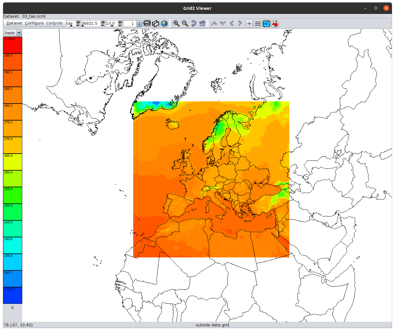