Dear THREDDS mailing list

We have set THREDDS up to host a WMS for some netCDF files.  These netCDF files
have a 5 km resolution and are in the EPSG:3035 coordinate reference system.
The metadata header for one of the netCDF files is as follows:

netcdf Z:/thredds/edge/edge-mockup-20160711-RCP2_6-ECMWF-NOAA-indicator01.nc {
  dimensions:
    time = UNLIMITED;   // (17 currently)
    x = 1000;
    y = 950;
  variables:
    float indicator(time=17, y=950, x=1000);
      :_FillValue = -9999.0f; // float
      :standard_name = "indicator01";
      :long_name = "indicator01";
      :units = "-";
      :RCP = "RCP2_6";
      :GCM = "ECMWF";
      :HYDROMODEL = "NOAA";
      :coordinates = "time y x";
      :grid_mapping = "lambert_azimuthal_equal_area";
      :missing_value = -9999.0f; // float
      :valid_min = 0.0; // double
      :valid_max = 22.8378; // double
      :_ChunkSizes = 6, 317, 334; // int

    int lambert_azimuthal_equal_area;
      :grid_mapping_name = "lambert_azimuthal_equal_area";
      :longitude_of_projection_origin = "10.0";
      :latitude_of_projection_origin = "52.0";
      :false_easting = "4321000.0";
      :false_northing = "3210000.0";
      :_CoordinateTransformType = "Projection";
      :_CoordinateAxisTypes = "GeoX GeoY";

    double lat(y=950, x=1000);
      :standard_name = "latitude";
      :long_name = "latitude coordinate";
      :units = "degrees_north";
      :_ChunkSizes = 475, 500; // int

    double lon(y=950, x=1000);
      :standard_name = "longitude";
      :long_name = "longitude coordinate";
      :units = "degrees_east";
      :_ChunkSizes = 475, 500; // int

    double time(time=17);
      :_FillValue = -9999.0; // double
      :long_name = "time";
      :units = "seconds since 2019-01-01 23:59:59";
      :calendar = "gregorian";
      :_ChunkSizes = 17; // int
      :_CoordinateAxisType = "Time";

    double x(x=1000);
      :standard_name = "projection_x_coordinate";
      :long_name = "x coordinate of projection";
      :units = "Meter";
      :_ChunkSizes = 1000; // int
      :_CoordinateAxisType = "GeoX";

    double y(y=950);
      :standard_name = "projection_y_coordinate";
      :long_name = "y coordinate of projection";
      :units = "Meter";
      :_ChunkSizes = 950; // int
      :_CoordinateAxisType = "GeoY";
}

Displaying the netCDF file via the Godiva 2 viewer in THREDDS seems to work as
expected, but when overlaying other datasets in other software packages (e.g.
QGIS, ArcGIS, etc.) there is a noticeable offset/error in the WMS images
generated by THREDDS.

To spot the offset, we load the WMS from THREDDS and the original source data
from the netCDF file as layers in QGIS.  In the attached image
(QGIS-error.png), you can clearly see that the grey (local netCDF file) layer
is not completely hidden by the green (THREDDS WMS) layer.

We assume that this is something to do with re-projection of the data?  Pulling
an image from the THREDDS WMS in the EPSG:3035 projection system yields the
same sort of offset.  A call with WMS parameters
SRS=EPSG:3035&BBOX=3615000,3550000,3620000,3555000 in our mind should return a
single pixel from the netCDF data, however it doesn't.

One other thing to note is that QGIS reports the source projection definition
as '+proj=laea +lat_0=52 +lon_0=10 +x_0=4321000 +y_0=3210000 +ellps=WGS84
+towgs84=0,0,0,0,0,0,0 +units=m +no_defs'  which differs from EPSG:3035 in its
datum.  However we don't think this should matter as the same netCDF file is
being processed by QGIS and THREDDS.

Therefore, should the coordinate reference system in the netCDF file be defined
in a different way or is there a bug in the ncWMS used by the THREDDS?


Many thanks for any help that people can provide, best wishes, Simon.
________________________________
This message (and any attachments) is for the recipient only. NERC is subject
to the Freedom of Information Act 2000 and the contents of this email and any
reply you make may be disclosed by NERC unless it is exempt from release under
the Act. Any material supplied to NERC may be stored in an electronic records
management system.
________________________________
Attachment:
QGIS-error.png
Description: QGIS-error.png
thredds archives: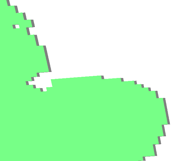