Hi Don,
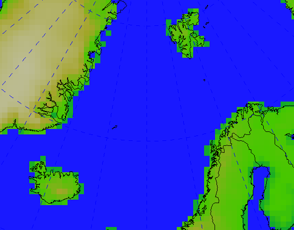
thanks a lot, the update of the World Coastlines map as you explained
gives huge improvements, see attached figure. And combining that with
the World Political Boundaries, updates even the European borders,
Serbia and Montenegro are both visible.
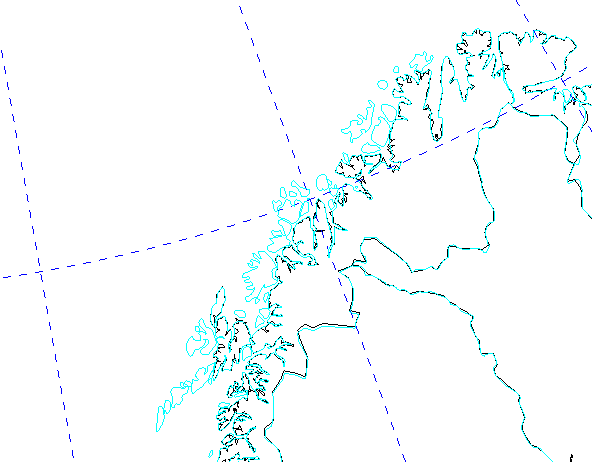
The McIdas map is definitely supperior, both to the World Coastlines +
World Political Boundaries as well as the World Country Borders. It has
Serbia, Montenegro and Iceland in the right place, and it adds several
island, i.e. Lofoten/Vesterålen in Northern Norway (see second figure:
black Coastlines + Political, blue McIdas), or the Isselmeer in the
Netherland.
Best wishes,

Heiko


Don Murray wrote:
Hi Heiko-

Thanks for pointing this out.  It's been difficult to get good, free maps.

A couple of notes:
- In the latest version of the IDV (2.7u1), the World Coastlines map was
updated to a higher resolution map. However, if you have ever changed
your default map preferences, then you will not see that map by default.
You can get the updated map by:
  - Open the Default Background Map Control window
  - Delete the World Coastlines map by clicking the trash can icon
  - Select the File->Default Maps->Save as Default Map set
  - Exit the IDV.

That will remove the old reference.

  - Restart the IDV
  - Open the Default Background Map control window
  - Select the Edit->Add System Map->World Coastlines map.
Alternatively, if you have not added or changed any of the other default
maps, you can use the File->Default Maps->Remove Local Map Defaults and
restart the IDV. That will pick up the new map and you can then save
that preference.
- I just added a new plugin with a better World Country Outline map.
- Use the Tools->Plugin Manager dialog to add in the Maps->World Maps
plugin.
- Restart the IDV.
- Use the Edit->Add System Map->McIDAS World Country Outlines to get
the new map.
If users like this map better, we can set that as the default World
Country Outline map. This is from the Unidata McIDAS distribution (as
is the new World Coastlines map). If there are any issues with this
map, please let us know so we can fix them.
Don Murray

Heiko Klein wrote:
I've been checking some altitude maps over Europe and got a bit
confused by using the default IDV (2.7u1) 'world country outlines'. It
seems like Iceland (lower left corner) is about 2 degrees more west
than the altitude, while Svalbard/Spitsbergen (upper right corner on
the attached figure) has only 5% of its actual size.
The same map looks okay with the World Coastlines, which is of lower
resolution.
I recognized, too, that the country borders don't reflect the split of
serbia and montenegro in 2006.
Does somebody have other country border or higher resolution world
coastline files available? Did somebody convert i.e. the recently
updated NCL / Ncar graphics database 'Earth..4' to an idv-readable file?
Best regards,

Heiko


------------------------------------------------------------------------

This body part will be downloaded on demand.
--
Dr. Heiko Klein                              Tel. + 47 22 96 32 58
Development Section / IT Department          Fax. + 47 22 69 63 55
Norwegian Meteorological Institute           http://www.met.no
P.O. Box 43 Blindern  0313 Oslo NORWAY