Satellite Imagery
Unidata has a special set of data products prepared at
the
Space Science and Engineering Center (SSEC)
at the
University of Wisconsin, Madison. One special feature
of this data stream is satellite imagery. For the most
part, the images are from Geostationary Orbiting
Environmental Satellites (GOES), but certain data from
other satellite observing platforms can be injected on
special request. Currently SSEC is the IDD injection point
for all satellite imagery.
High Interest Images
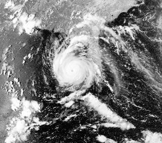
Hurricanes generate some of the highest interest in weather
data on the Internet. The
University of Michigan used
its Unidata systems to capture this
images of Hurricane Andrew and make it available on
their WWW server.
Composite Weather Maps
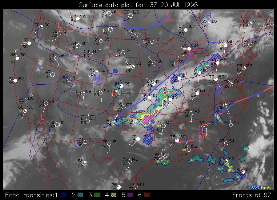
In this map generated at
Purdue
, an infrared satellite image provides
the background for the conventional data from the Domesitic Data Service.
The satellite image is delivered via
the IDD from the University of Wisconsin Space Science and Engineering Center
(SSEC). To generate the map, the Unidata Local Data Manager (LDM) software
(which is the heart of the IDD at each site) is constantly
capturing data both from the Domestic Data Service stream and satellite imagery
stream from SSEC. The LDM can be configured to spawn an applications program
upon the receipt of certain data products. The application program, Purdue's
WXP in this case, is used to generate the composite map.
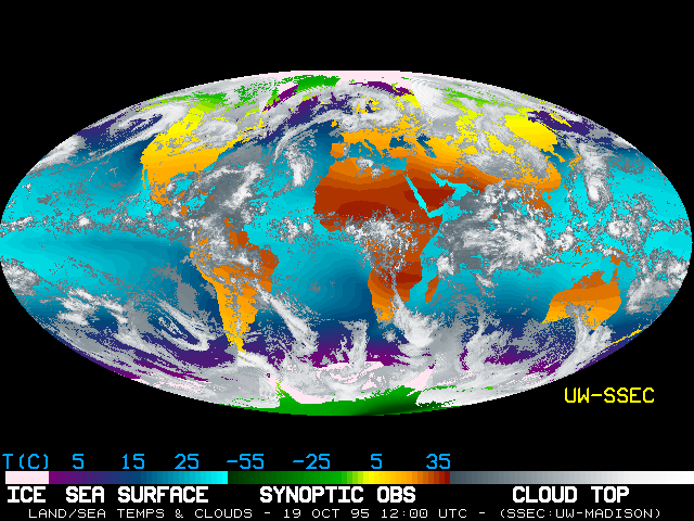
Global Information
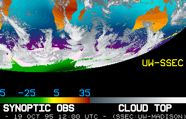
Data from a number of different observing platforms
can be combined to
provide a global coverage of the planet. The SSEC Global Montage displays these
data in a striking image. Data from several satellites show the cloud cover
and sea surface temperatures, while conventional surface observations (referred to
as "Synoptic Obs" in the legend) are shown as color contours on the land masses.
This dramatic display of the state of the globe is generated every six hours
at the University of Wisconsin. Note that not all the satellite data in this image
is currently being distributed via the IDD, but the IDD is capable of carrying it.
The data from the international ground observing stations are delivered from
the International Data Service (IDS) which is available on a regular basis
via the IDD.
 In this map generated at Purdue
, an infrared satellite image provides
the background for the conventional data from the Domesitic Data Service.
The satellite image is delivered via
the IDD from the University of Wisconsin Space Science and Engineering Center
(SSEC). To generate the map, the Unidata Local Data Manager (LDM) software
(which is the heart of the IDD at each site) is constantly
capturing data both from the Domestic Data Service stream and satellite imagery
stream from SSEC. The LDM can be configured to spawn an applications program
upon the receipt of certain data products. The application program, Purdue's
WXP in this case, is used to generate the composite map.
In this map generated at Purdue
, an infrared satellite image provides
the background for the conventional data from the Domesitic Data Service.
The satellite image is delivered via
the IDD from the University of Wisconsin Space Science and Engineering Center
(SSEC). To generate the map, the Unidata Local Data Manager (LDM) software
(which is the heart of the IDD at each site) is constantly
capturing data both from the Domestic Data Service stream and satellite imagery
stream from SSEC. The LDM can be configured to spawn an applications program
upon the receipt of certain data products. The application program, Purdue's
WXP in this case, is used to generate the composite map.
 Data from a number of different observing platforms
can be combined to
provide a global coverage of the planet. The SSEC Global Montage displays these
data in a striking image. Data from several satellites show the cloud cover
and sea surface temperatures, while conventional surface observations (referred to
as "Synoptic Obs" in the legend) are shown as color contours on the land masses.
This dramatic display of the state of the globe is generated every six hours
at the University of Wisconsin. Note that not all the satellite data in this image
is currently being distributed via the IDD, but the IDD is capable of carrying it.
The data from the international ground observing stations are delivered from
the International Data Service (IDS) which is available on a regular basis
via the IDD.
Data from a number of different observing platforms
can be combined to
provide a global coverage of the planet. The SSEC Global Montage displays these
data in a striking image. Data from several satellites show the cloud cover
and sea surface temperatures, while conventional surface observations (referred to
as "Synoptic Obs" in the legend) are shown as color contours on the land masses.
This dramatic display of the state of the globe is generated every six hours
at the University of Wisconsin. Note that not all the satellite data in this image
is currently being distributed via the IDD, but the IDD is capable of carrying it.
The data from the international ground observing stations are delivered from
the International Data Service (IDS) which is available on a regular basis
via the IDD.