NOTE: The galeon mailing list is no longer active. The list archives are made available for historical reasons.
Arliss, Ben,

First, my thanks to Ben for kicking off this discussion, which I think
highlights some key aspects of interest to the met/ocean domains. My
perspectives are inline below.
Arliss, As usual, your questions get right to the heart of the matter. I'll start with my own quick response, with the caveat that other GALEON participants will have perhaps different views (especially on the priorities) and more detailed input as we progress. My responses: 1) Which type(s) of ISO 19123 coverage is this? Gridded Data Structured DiscreteGridPointCoverage Swath DiscreteSurfaceCoverage Point Observation Data Unconnected DiscretePointCoverage Station observation /Timeseries DiscretePointCoverageTrajectoryGeneral DiscretePointCoverage or DiscreteCurveCoverage Profile DiscretePointCoverage Radial DiscreteSurfaceCoverage or DiscreteCurveCoverage
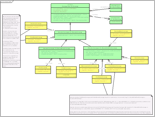
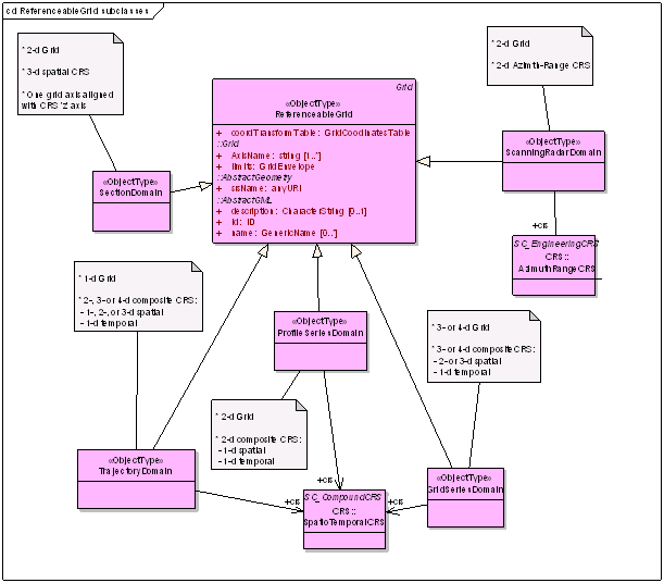
I agree pretty closely with Ben here. See attached picture for the
relationships we use in CSML (http://ndg.nerc.ac.uk/csml/).

We also make considerable use of the CV_ReferenceableGrid subclass for various
domain geometries of the CV_DiscreteGridPointCoverage:
2) What domain dimensions are needed?

One of the main points of the aviation-related local forecast use case
is to emphasize the need for full 3D plus model-run-time and
valid-forecast-time. There is also a need for "time relative to the
present" e.g. the latest forecast or observations during the last two
hours.   Moreover, in the research community, there will be a demand for
access to the "raw" data which, in many cases, includes an elevation
dimension which is non-spatial, e.g., pressure in the atmosphere or
density in the ocean.  Perhaps this last topic belongs in the response
to the next question relating to axes.
The above diagram (from the CSML User's Manual) illustrates a number of
spatio-temporal domain dimensions we require. As Ben mentions, we also
use non-length-based coordinates, mainly in the vertical. We believe the
new ISO 19111-2 allows such coordinate systems to be integrated with
more traditional CRS; the real development needed here is just to
catalogue the things (aka EPSG) so the community can reference them. The
British Atmospheric Data Centre plans to do this as part of its CF work.
3) What range data structures are needed (called fields and axes in WCS
1.1)?

I may have covered some of the needs for special "axes" in item 2)
above.  But, in general, this is going to require more research on my
part.  If I understand it correctly, the actual data structures for the
fields will be different for different data categories and, in some
cases, will be different for different fields within a dataset.  This is
the area where most of the work is needed in order to come up with
"application profiles."
One issue we're grappling with right now is whether you should regard
(for instance) the individual time-series measure at a fixed station as
part of the same feature/coverage, or whether they should be modelled
with separate identities. E.g. we may have diurnal observations of
temperature min/max, but wind measurements every 15 minutes. They don't
share the same (temporal) domain, but are really both from the same AWS.
4) What are the relative priorities among these types of data?

Below are Ben's priorities expressed in terms of the order in which
Unidata will be working on them

(But please NOTE WELL that others will have other priorities, e.g., the
coastal ocean modelling community will be working on irregular grids
first whereas hydrology folks will probably be most interested in
station obs and radar)

1. Structured Grids (the main focus of GALEON 1 and the CF conventions
for netCDF)
2. Station Observations (Currently working on netCDF conventions for
Observational datasets)
3. Vertical Profiles (e.g. wind profiler data, balloon or moored buoy
CTD soundings)
4. Point Data (e.g. lightning strike data)
5. Radar Radial (e.g., NEXRAD level 2 volume scans)

Perhaps some of this would be useful for discussion during the GALEON
session at Wednesday's WCS.SWG telecon.

-- Ben
galeon archives: