NOTE: The galeon mailing list is no longer active. The list archives are made available for historical reasons.
Another question concerns using of the gml:RectifiedGrid is the grid coordinate values defined by gml:low and gml:high. The WCS return of the example getCoverage request posted by Rudy bellow:
<http://webapps.datafed.net/dvoy_services/ogc.wsfl?SERVICE=wcs&REQUEST=GetCoverage&VERSION=1.0.0&CRS=EPSG:4326&COVERAGE=THREDDS_GFS.T&FORMAT=GML&BBOX=-180,-90,180,90,1350,1350&TIME05-12-06T12:00:00Z&WIDTH=900&HEIGHT=400&DEPTH=0>is a grid, in GML, with grid origin at (-90,-180), i.e., <gml:pos>1133870400000 1350 -90 -180</gml:pos> (note that I only focus on the lat/lon dimensions for simplicity) and grid coordinate values being <gml:low>0 0 0 0</gml:low> and <gml:high>0 0 72 72</gml:high>. It seems that the returned grid has 72 rows and 72 columns, which is not consistent with the "width=900 & height=400" in the request. The "width=900 & height=400" means that the returned grid should have 900 columns and 400 rows. I don't know how the values in gml:low and gml:high were determined.
I try to ask my question regarding the gml:low/gml:high by using examples and hope that someone can help me out. I'll just list partial elements rather than a complete gml:RectifiedGrid for simplicity. I also omit the crs name and assume it's in EPSG4326:
Assume there is a WCS returned grid, named GRID-A, described by the following gml
Axes: <gml:axisName>Lat</gml:axisName>  and  <gml:axisName>Lon</gml:axisName>
Envelope: <gml:low>0 0</gml:low> and <gml:high>10 10</gml:high>
Origin:  <gml:pos> -90 -180</gml:pos>
Offset: <gml:offsetVector>1.0 0.0</gml:offsetVector> and <gml:offsetVector>0.0 2.0</gml:offsetVector> This gml shows a WCS returned grid with origin at (-90, -180), having 10 rows and 10 column, with cell spaces of 1.0 degrees in latitude direction and 2.0 degrees in longitude direction. Thus, the grid covers from (-90,-180) to (-80,-160).
Now, consider another WCS returned grid, named GRID-B, with everything the same as the above GRID-A, except that the gml:low/gml:high values are different, which are <gml:low>10 10</gml:low> and <gml:high>20 20</gml:high>:
Axes: <gml:axisName>Lat</gml:axisName>  and  <gml:axisName>Lon</gml:axisName>
Envelope: <gml:low>10 10</gml:low> and <gml:high>20 20</gml:high>
Origin:  <gml:pos> -90 -180</gml:pos>
Offset: <gml:offsetVector>1.0 0.0</gml:offsetVector> and <gml:offsetVector>0.0 2.0</gml:offsetVector>
Question: what are the spatial coverage and origin of this GRID-B? I am not sure which one of the the followings is correct:
1. GRID-B covers from (-80,-160) to (-70,-140) because it starts from <gml:low>10 10</gml:low>. If this is true, then the 10-row by 10-column grid's origin is NOT at (-90,-180). The origin should be at (-80,-160).
2. GRID-B covers from (-80,-160) to (-70,-140) because it starts from <gml:low>10 10</gml:low>. It's origin is at (-90,-180) but the origin is outside the 10x10 returned grid. If this is true, what is the usefulness of this origin information? What is it different from saying: the grid's origin is at (+10,+10), or anywhere else?
3. GRID-B covers from (-90,-180) to (-80,-160), as does the GRID-A, and thus its origin is correctly stated as (-90,-180). However, it has grid coordinate extends from (10,10) to (20,20). If this is true, what does this "grid coordinate extents" means? Is there any difference between referring a 10x10 array to being (10,10) to (20,20) and referring it to being (0,0) to (10,10)?
4. Any other difference between GRID-A and GRID-B?When considering these questions, it should keep in mind that we are talking about using gml describing a grid already produced by a WCS server and returned to a WCS client. We are not talking about subsetting from a source grid. It's obvious that gml:low/gml:high can be used to specify a subset of a source coverage, i.e., from gml:low to gml:high.
Also notice that for in many data formats, there is no such thing as to saying a 10x10 array beginning from (10,10) and ending at (20,20), or any other values such as (r0,c0) to (r0+10,c0+10). The offsets, r0 and c0 in terms of row and column numbers, are simply useless. For example, in HDF-EOS, it specifies the geoinformation for the first and last row/col of an array. There is no place to say that this array is starting from (r0,c0) to (r0+10,c0+10) because the (r0,c0) information is of no use. I believe that it is similar in GeoTiff, where image array's row/col numbers are defined by imageWidth/ImageLength tags. The tie points are defined in reference to the first row/col (e.g., geo-x/y values for first r/c, 3rd r/c, 10th r/c, etc), rather than in reference to absolute r/c numbers such as geo-x/y values for row 10001 and col 2001 of a 10r by 10c image with r/c ranging from (1000,2000) to (1010,2010).
Regards.

Wenli Yang
George Mason University

At 01:37 2006-2-27 -0600, Rudolf Husar wrote:
Gerry,The use of multiple 'languages' e.g. GML and SensorML seems to me the only way to describe the different aspects of Earth Science monitoring and data systems. This may be naive, but my question is not whether but how to use the combination of these standard languages to describe the entire elephant. Some early, thinking-fragments on this topic, related to air quality is here.<http://capita.wustl.edu/capita/researchareas/GALEON/Reports/AQ_Pt_OGC.ppt>http://capita.wustl.edu/capita/researchareas/GALEON/Reports/AQ_Pt_OGC.ppt Ron,Expanding on Ben's comment, GML (rectified grid) is one of the WCS data formats returned from (some of the) test servers in GALEON, e.g. <http://webapps.datafed.net/dvoy_services/ogc.wsfl?SERVICE=wcs&REQUEST=GetCoverage&VERSION=1.0.0&CRS=EPSG:4326&COVERAGE=THREDDS_GFS.T&FORMAT=GML&BBOX=-180,-90,180,90,1350,1350&TIME=2005-12-06T12:00:00Z&WIDTH=900&HEIGHT=400&DEPTH=0>http://webapps.datafed.net/dvoy_services/ogc.wsfl?SERVICE=wcs&REQUEST=GetCoverage&VERSION=1.0.0&CRS=EPSG:4326&COVERAGE=THREDDS_GFS.T&FORMAT=GML&BBOX=-180,-90,180,90,1350,1350&TIME=2005-12-06T12:00:00Z&WIDTH=900&HEIGHT=400&DEPTH=0All,FYI, George Percivall, Chief Architect of OGC, has prepared this PPT on the OGC Networks, including the GEOSS Services Network, (GSN)<http://portal.opengeospatial.org/files/index.php?artifact_id=13947>http://portal.opengeospatial.org/files/index.php?artifact_id=13947 Rudy Professor of Mechanical Engineering, Director CAPITA, Washington University St. Louis, MO 63130 1 Brookings Drive, Box 1124 314 935 6099On 2/26/06, Gerry Creager N5JXS <<mailto:gerry.creager@xxxxxxxx>gerry.creager@xxxxxxxx> wrote:I'd like to offer the thought that we need to consider SensorML, as well as GML, or potentially ESML, to allow description of datasets and sensors involved in this work. Gerry
Attachment:
rectifiedGrid.jpg
Description: JPEG image
galeon archives: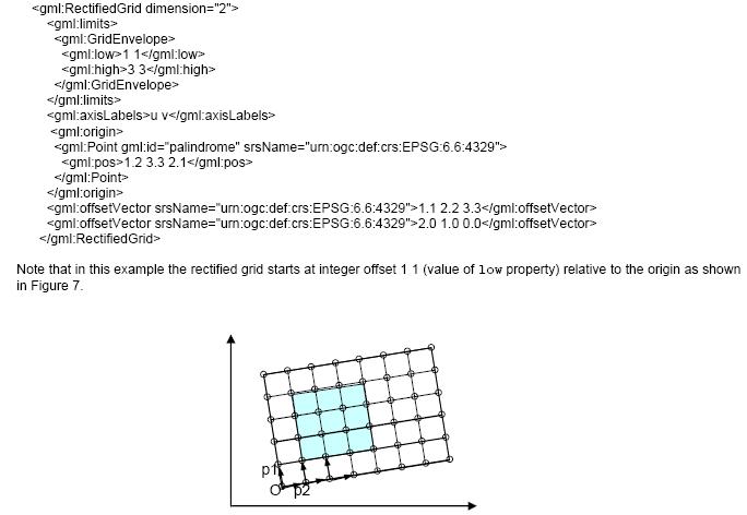