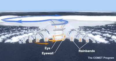
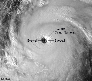
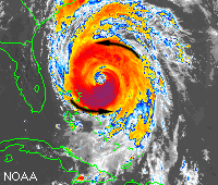
The dense wall of thunderstorms surrounding the eye has the strongest winds within the storm. Changes in the structure of the eye and eyewall can cause changes in the wind speed, which is an indicator of the storm's intensity. The eye can grow or shrink in size, and double (concentric) eyewalls can form. The Spiral Rainbands The storm's outer rainbands (often with hurricane or tropical storm-force winds) can extend a few hundred miles from the center. Hurricane Andrew's (1992) rainbands reached only 100 miles out from the eye, while those in Hurricane Gilbert (1988) stretched over 500 miles. These dense bands of thunderstorms, which spiral slowly counterclockwise, range in width from a few miles to tens of miles and are 50 to 300 miles long. Sometimes the bands and the eye are obscured by higher level clouds, making it difficult for forecasters to use satellite imagery to monitor the storm. |
|
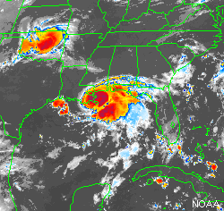
| Hurricane Size Typical hurricanes are about 300 miles wide although they can vary considerably, as shown in the two enhanced satellite images below. Size is not necessarily an indication of hurricane intensity. Hurricane Andrew (1992), the most devastating hurricane of this century, was a relatively small hurricane. |
|
|
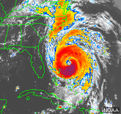
| Do not focus on the location and track of the center, because the hurricane's destructive winds and rains cover a wide swath. Hurricane-force winds can extend outward to about 25 miles from the storm center of a small hurricane and to more than 150 miles for a large one. The area over which tropical storm-force winds occur is even greater, ranging as far out as almost 300 miles from the eye of a large hurricane. |
Hurricane Circulation and Movement In the northern hemisphere, hurricane winds circulate around the center in a counter-clockwise fashion. This means that the wind direction at your location depends on where the hurricane's eye is. A boat on the northern edge of the orange area in Hurricane Fran (right) would experience winds from the east, while a boat on the southern edge would have westerly winds.
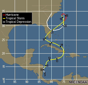
Typically, a hurricane's forward speed averages around 15-20 mph. However, some hurricanes stall, often causing devastatingly heavy rain. Others can accelerate to more than 60 mph. Hurricane Hazel (1954) hit North Carolina on the morning of 15 October; fourteen hours later it reached Toronto, Canada where it caused 80 deaths. Some hurricanes follow a fairly straight course, while others loop and wobble along the path. These seemingly erratic changes are difficult to forecast and will be discussed in more detail in the Forecasting section of this module. |
|||
|
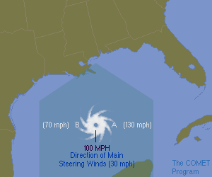
The Right Side of the StormAs a general rule of thumb, the hurricane's right side (relative to the direction it is travelling) is the most dangerous part of the storm because of the additive effect of the hurricane wind speed and speed of the larger atmospheric flow (the steering winds). The increased winds on the right side increase the storm surge described in the Hazards section of this module. Tornadoes are also more common here.Looking at the figure above, pretend you are standing behind the hurricane with your back to the steering flow. In this case, the right side is the eastern section of the hurricane. (If it were travelling east to west, the right side would be the north section.) The winds around the hurricane's eye are moving in a counterclockwise fashion. At Point A, the hurricane winds are nearly in line with the steering wind, adding to the strength of the winds. For example, if the steering currents are 30 mph and the average hurricane winds are 100 mph, the wind speed would be 130 mph at Point A. On the other hand, the winds at Point B are moving opposite those of the steering wind and therefore slow to 70 mph (100 - 30 mph). Incidentally, NHC forecasts take this effect into account in their official wind estimates. |