HYDRO-NEXRAD Report: April
2009
Mohan Ramamurthy and Jeff Weber
To maintain a vibrant program, the
UPC, from time to time, participates in certain projects that are tied to its
overall mission but funded separately from the core program. Such synergistic activities are both
essential and complementary to the core effort, and both the Policy Committee
and NSF encourage them. Such projects have played a vital role in advancing the
program in new directions, creating new capabilities for the community, enhancing
interoperability of Unidata software, providing new datasets to the community,
and entraining and diffusing innovative ideas and technologies into the
community.
Continued progress was made to advance HYDRO-NEXRAD ITR project goals
during last year. However, the severe flooding in Iowa City, Iowa during the summer months resulted in prolonged interruptions and
outages at the University of Iowa and delayed the ongoing work by over two
months, with many of the systems and servers used in the project not fully
functional until the end of August 2008. [In the wake of the severe flooding,
the NSF Director, Dr. Arden Bement, visited the University of Iowa and the project PIs, Profs. Witek Krajewski and Anton Kruger,
had an opportunity to present some of their ongoing work to Dr. Bement,
including some of the data and products from this project. Unidata
provided access to archived data to help fill in gaps due to power and hardware
failures to aid in the demonstration.]
The Iowa PIs, in collaboration with Unidata, have submitted a
supplemental request for the continuation of the project. As such, it is important to continue the
ongoing efforts to provide a smooth transition to the continuation project.
In this annual report, we
summarize Unidata’s activities pertaining to the HYDRO-NEXRAD ITR project during
the past year.
1. Continued
Provision of NEXRAD Level II Radar Data and Adaptation to Super Resolution Data
Unidata continues to supply the University
of Iowa with a top-level feed for Level
II radar data using the LDM/IDD. Originally,
the data feed included only 10 radars of interest, but during the last year that
number was expanded to include 40WSR-88D sites. Recently, the National Weather Service began a
major upgrade to the resolution of the Level II radar data. The so-called “super resolution” (Build 10) data
provides reflectivity data with 0.5 degree resolution in azimuth and 250 m
resolution in range. The super resolution data present an important opportunity
for the hydrologic community given the high variability of the runoff
generation processes in urban environments.
Unidata has already adapted its decoders and applications to ingest the
super resolution data format and are currently working with the Iowa
team to ensure that the HYDRO-NEXRAD system can use the higher resolution data
feed.
In addition to providing WSR-88D Level II radar data,
Unidata provided 1 km national radar mosaic products to the Iowa PIs to fill in
gaps in data caused by format change of Level II data.
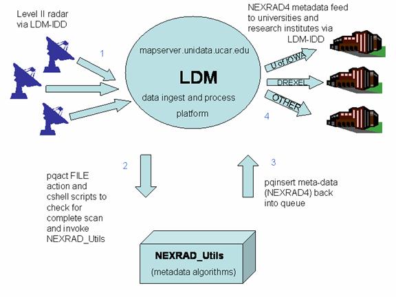
2. HYDRO-NEXRAD Feed
and Generation of Level II Metadata
Last year, Unidata created a new type of data feed for the
hydrology community. Unlike traditional
data feeds that distribute only the data in real-time, the new feed called
NEXRAD4 or HYDRO augments value-metadata for individual radars, basins, and
points of interest (rain gauge locations) along with the original radar data. Metadata include hydrologically meaningful
characteristics of rainfall (mean area rainfall, fractional basin coverage,
maximum rainfall amount, etc.). As a
result, the HYDRO-NEXRAD feed is a significant step to facilitate data mining
and knowledge extraction from the vast volumes of radar data. Below is a
schematic of the process:
Researchers at the University of Iowa continue to develop additional metadata
descriptions as well as new algorithms for metadata generation. As those algorithms become ready for
operational deployment, Unidata has been implementing those algorithms and
augmenting the Level II radar data feeds through a new LDM/IDD HYDRO feed. Unidata and University of Iowa PIs mutually agreed last year that Unidata will begin
generating the value-added metadata locally and then distribute the metadata
and Level II files in the new HYDRO-NEXRAD feed.
Unidata is also
working closely with Prof. David Maidment, University of Texas, Austin, and head of CUAHSI-HIS group and his
students toward creating a metadata database for use with the CUAHSI long term
hydrologic observatories.
3. NEXRAD-ITR MapServer
at Unidata
During the past year, we continue to develop, test and
deploy a dedicated MapServer at the Unidata
Program Center,
enabling the availability of the MapServer
to Unidata’s large user community. Specifically,
the UPC staff tested and provided feedback on the MapServer GUI. Work is underway to prepare the Unidata
MapServer to become a node for HYDRO-NEXRAD services in the future.
4. Future
Jeff Weber visited the University
of Iowa in June to discuss project
priorities for the next year, especially for Unidata. Those discussions and conference calls with
the Unidata PI resulted in the identification of the following tasks for
Unidata for the next year, and a submittal of a supplemental request to NSF to
continue the project for another two years.
The recent switch by the National Weather Service to the
super-resolution data collection by most of the WSR-88D radars has resulted in
the re-coding of the ingestors and the development of the databases for
radar-based and basin-based metadata.
The codes Iowa researchers
provided to Unidata to calculate the metadata no longer work and the migration
of those codes for the super-resolution radar data will be a high priority
activity during the extension period.
The Unidata Program
Center will continue to assist the
project PIs in that transition by updating the Hydro data feed and aiding in
the expansion of the feed to calculate metadata for all 158 radars. The current
codes do not scale for efficient use with 150 radars in real-times. The UPC and Iowa
developers are working together to use a C-based code from GEMPAK to perform
that task. Simultaneously, we are also exploring ways to organize the
Java-based calculations to make them faster and more efficient.
The UPC staff are continuing to
test and provide feedback on the HYDRO-NEXRAD MapServer GUI. We anticipate that the MapServer that is
maintained at Unidata will become a node for HYDRO-NEXRAD services during the
upcoming year. Entrainment of more users for the HYDRO feed and the database is
another goal for the project during the next year.
In addition to the above work, Unidata will continue to
provide other support as necessary toward fulfilling the goals of the project
and to facilitate a smooth transition of the project resources toward meeting
the needs of the hydrology community. In addition, the results and products
from the project will be disseminated to the Unidata community and our
governing committees at their regular meetings.
5. Current State
This project is ongoing, yet static, we
await possibilities for future funding and new directions.