[Date Prev][Date Next][Thread Prev][Thread Next][Date Index][Thread Index]
20001222: Re: Meso Eta change to SST (fwd)
- Subject: 20001222: Re: Meso Eta change to SST (fwd)
- Date: Fri, 22 Dec 2000 09:04:52 -0700
ord version of this Memo

Memo
To      Users of NOAA/NWS/NCEP/EMC Eta forecast model
From    NOAA/NESDIS/ORA/ORAD and NOAA/NWS/NCEP/EMC
Subject Use of NESDIS 50-km SST analysis in EMC's Meso Eta model
Date    21st December 2000

This memo addresses some of the concerns raised by Geoff DiMego's
message dated 19th December 2000 concerning "Meso Eta change to SST".

As indicated by Geoff in the first paragraph of his message, the Meso
Eta model has been overly active along the Atlantic Coast and Great
Lakes region this season.  Since high SSTs assist in cyclogenesis,
NCEP/EMC decided to investigate the validity of the SST analysis that
was being used in the Eta modeling system.

It was noted that the ETA analyzed SST field using the NESDIS 50-km
product was up to 8 °C warmer (e.g. 12Z model run, 19th Dec 2000) than
when using the NCEP 1°×1° analysis, with the difference being greatest
in the Gulf Stream region northeast of Cape Hatteras. Preliminary
investigations by EMC's Ocean Modeling Branch comparing buoy
temperatures with Reynolds' and NESDIS SST analyses indicated that the
latter could be warmer by up to 5 °C in some regions.  There were also
indications that the Eta modeling system produced too much precipitation
in response to the warmer and moister boundary layer over the Gulf
Stream Region.

Late in November EMC noticed that the Great Lake satellite water
temperatures provided by NOAA's Great Lakes Environmental Research
Laboratory (GLERL) weren't changing.  GLERL verified that it had been 27
days since they had been able to update their temperatures due to
persistent cloud cover.  By December 3rd they corrected their sea
surface temperature product resulting in cooler temperatures of 3 to 6
degrees more appropriate for this time of year.  Since the 8th of
December GLERL has again had difficulty updating their product over the
Great Lakes due to persistent cloud cover.

Based on the analysis of these two satellite products by EMC, a decision
was made to replace the source of the sea surface temperature fields
used in the meso Eta. Starting at 18Z on the 20th of December, the
NESDIS 50-km SST analysis and GLERL Great Lakes SSTs were replaced by
the Reynolds' SST analysis until the issues can be understood and
resolved.  NESDIS became aware of the change on the 20th of December and
investigated the problem with the following
results.


1)      The NESDIS 50-km analysis is a satellite-only product, whereas the
Reynolds analysis makes use of in situ SSTs from buoys and ships, using
satellite data to fill the gaps by optimal interpolation.

2)      Both the Atlantic and Great Lakes regions are heavily cloud-covered
at this time of year, leading to relatively few satellite retrievals on
a daily basis.  The Great Lakes temperatures reported by GLERL have, in
some cases, not been updated for nearly a month due to cloud cover.

3)      In the case of the Eta 12Z model run on 19th December, much of the
Atlantic region had been heavily cloud covered for a number of days
beforehand, although some SST retrievals over the Gulf Stream from AVHRR
passes the day before were possible.  However, these data were too late
to be included in the 10 - 16 December Reynolds SST analysis, which was
therefore relying heavily on in situ measurements.  In this regard,
moored buoys were only obtainable close to the coast and in the open
ocean, too far East and South of the area of interest, while no drifting
buoys were present in the area.

4)      Thus, two things need to be considered when drawing conclusions from
the comparisons made by EMC Ocean Modeling Branch.  First, the coastal
nature of the buoys showing the greatest discrepancy with the NESDIS
50-km analysis can be explained by the high gradients in the local
region (cool shelf vs. warm Gulf Stream waters off the coast).  These
comparisons should be done using 1-km (or at worst 4-km) resolution
satellite data.  Note also that there are no comparison points in the
critical area of interest.  Second, in the heavily cloud-contaminated
period during which the most recent Reynolds analysis was generated, the
absence of satellite data will have caused the scheme to revert to
straightforward interpolation between the relatively widely-spaced in
situ data.  The EMC/OMB comparison between buoy temperatures and
Reynolds is therefore pitting in situ vs. in situ, and will inevitably
result in good bias figures.

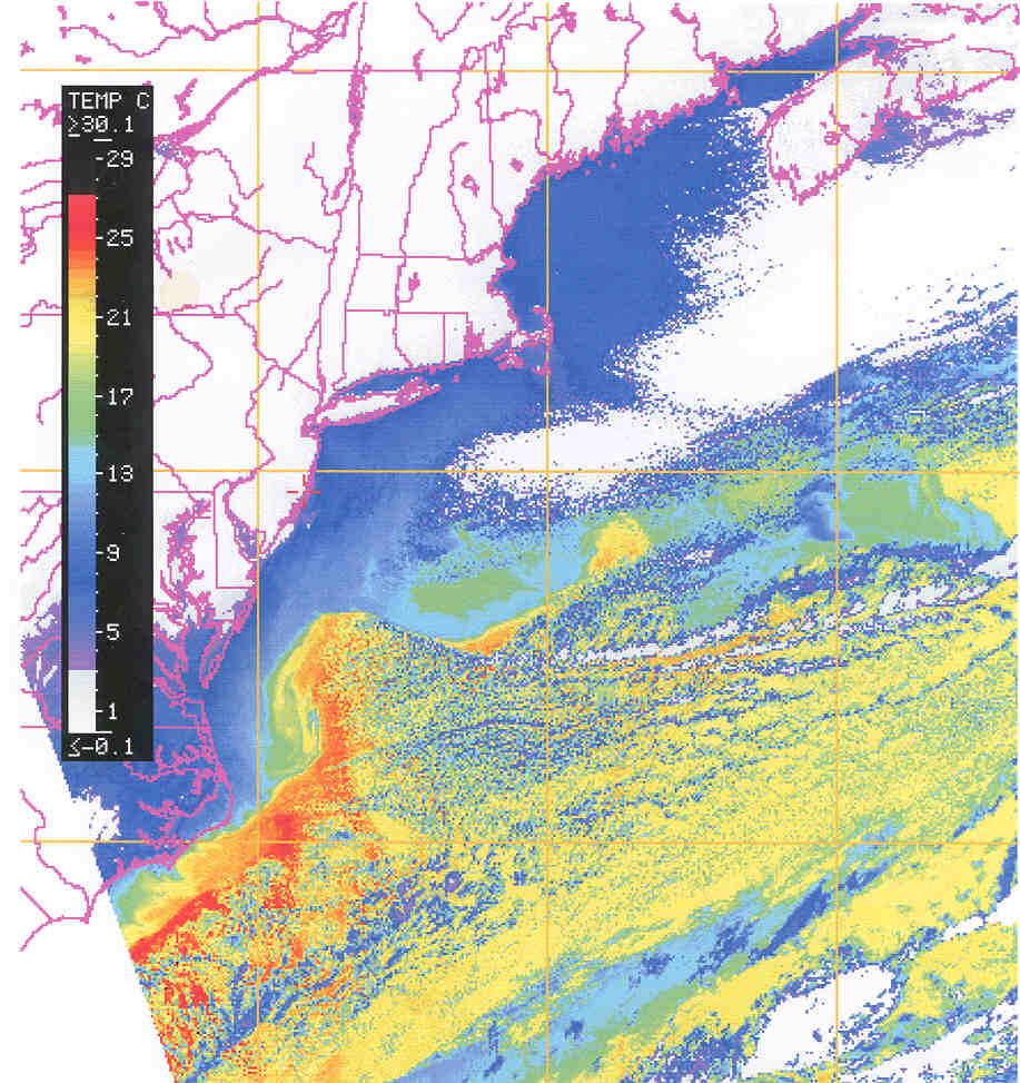
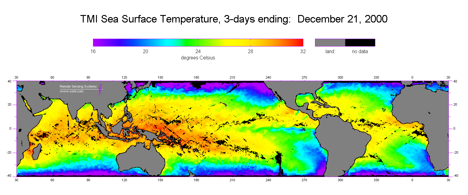
5)      Finally, the question remains as to whether the warmer SSTs in the
NESDIS 50-km analysis for 19th December are real.  1-km AVHRR SST
imagery over the Northeast Atlantic coastal region for 18th December
(Figure 1) clearly shows a Northward-protruding meander with water
temperatures of about 23-24°C, whereas the surrounding shelf water is
10-15°C.  In support of this observation, SST retrievals (see Figure 2)
from the TRMM Microwave Imager (courtesy of Remote Sensing Systems,
Santa Rosa, CA) show the same feature with similar temperatures.

The linkage between the SST field and the modeling system require a
better understand and that operational decisions require better
coordination among the partners (NWS/NCEP/EMC and NESDIS/ORA/ORAD)
responsible for production and use of the SST products. The
characteristics and limitations of the various products will be better
understood. This is particularly important when intercomparing products
and validating against in situ.

Our recommendations are as follows:

i)      Improve the working relationship between NWS/NCEP/EMC and
NESDIS/ORA/ORAD to enable both an immediate resolution of problems and
development of high-resolution satellite-only and combined products that
are more specifically tailored to modeling requirements.

ii)     We will work jointly towards an optimum methodology for product
quality assurance.  Comparison of satellite SST retrievals and in situ
data should be done at the highest possible resolution in space and time
in order to minimize errors not directly related to the retrieval
process.

iii)    Cloud cover is the implacable enemy of SST retrieval from infrared
satellite sensors, and methods must be developed to minimize its impact
on the operational SST analyses.  Suggestions include:
a)      Use of high temporal resolution data (e.g. from GOES-Imager) to
'dodge' the clouds, where possible,
b)      Use of passive microwave data, where available, to obtain
low-resolution (50-km) retrievals in cloudy conditions
c)      Correct propagation of old SST observations by variational
assimilation into a dynamical ocean model.  This will require adequate
characterization of the observation error covariances in the various
regions.  These efforts will benefit from collaborations that are being
developed with NAVOCEANO under the GODAE initiative,
d)      Use of climatological and other information in the production of
surface temperature analyses will be necessary in order to avoid the
problem of fields remaining static in the case of persistent cloud
cover.

iv)     EMC will continue to investigate the reasons for increased
cyclogenetic activity this winter compared to last.  In addition, as SST
field improvements and enhancements are developed, it will apply
parallel testing of them.  In this way, the impact of the changes on the
Eta modeling system can be assessed and measured.


The following is the original e-mail sent 19 December 2000.


NCEP's Central Operations has just informed me that
the change (discussed below) will be made with the 18z
run of the Meso Eta today (12/20/00).


Folks:

This season, we have seen a fairly active character to the Meso
Eta along the Great Lakes and Atlantic Coast.  It has been more
active than either the NGM or the AVN.  We have looked into the
Sea Surface Temperature (SST) fields used in the models.  Both
the NGM and the AVN use a 1 degree by 1 degree product (the so-
called Reynolds analysis), whereas the Meso Eta uses a different
analysis on a 50 km grid (MCSST - multi-channel NESDIS product).
The latter product has high resolution Great Lake temperatures
added that are provided by GLERL (Great Lakes Environmental
Research Laboratory).  To make a long story short, we have had
(are having) problems with both of the sources of SST information
for the Meso Eta runs.

First, late in November Eric Rogers noticed that the GLERL
temperatures weren't changing.  GLERL verified that it had been
27 days since they had been able to update their temperatures
due to lack of satellite SST's (too much cloud) leaving them 3-6
degrees too warm.  By December 3rd this problem had been corrected
(for the time being - we've seen little change since the 8th).
This was occurring during same period that various data sources
(e.g. Canadian RAOB's) were missing due to comm's problems.

Second, with help from EMC's Ocean Modeling Branch, we have
verified that the MCSST analysis of the Gulf Stream was warmer
than either the 1 degree Reynolds analysis or buoy data.  Several
spots were 5 degrees or more too warm.  Problems with NESDIS'
NOAA-14 SST's have been implicated by NESDIS.  We have just filed
a request for an emergency change to turn off the use of the MCSST
and GLERL temperatures (not easily separated) and replace them
with the 1 degree analysis until the problems can be resolved.
The use of the Reynolds analysis produces 1-2 degree colder lake
temperatures than GLERL's current values (again - not changed since
the 8th).

Now all three models will be using the same daily SST analysis.

---------- End Forwarded Message ----------
--- Begin Message ---
- Subject: Re: Meso Eta change to SST
- Date: Fri, 22 Dec 2000 10:13:04 -0500
see also attached figures and MS Word version of this Memo

Memo
To      Users of NOAA/NWS/NCEP/EMC Eta forecast model
From    NOAA/NESDIS/ORA/ORAD and NOAA/NWS/NCEP/EMC
Subject Use of NESDIS 50-km SST analysis in EMC's Meso Eta model
Date    21st December 2000

This memo addresses some of the concerns raised by Geoff DiMego's
message dated 19th December 2000 concerning "Meso Eta change to SST".

As indicated by Geoff in the first paragraph of his message, the Meso
Eta model has been overly active along the Atlantic Coast and Great
Lakes region this season.  Since high SSTs assist in cyclogenesis,
NCEP/EMC decided to investigate the validity of the SST analysis that
was being used in the Eta modeling system.

It was noted that the ETA analyzed SST field using the NESDIS 50-km
product was up to 8 °C warmer (e.g. 12Z model run, 19th Dec 2000) than
when using the NCEP 1°×1° analysis, with the difference being greatest
in the Gulf Stream region northeast of Cape Hatteras. Preliminary
investigations by EMC's Ocean Modeling Branch comparing buoy
temperatures with Reynolds' and NESDIS SST analyses indicated that the
latter could be warmer by up to 5 °C in some regions.  There were also
indications that the Eta modeling system produced too much precipitation
in response to the warmer and moister boundary layer over the Gulf
Stream Region.

Late in November EMC noticed that the Great Lake satellite water
temperatures provided by NOAA's Great Lakes Environmental Research
Laboratory (GLERL) weren't changing.  GLERL verified that it had been 27
days since they had been able to update their temperatures due to
persistent cloud cover.  By December 3rd they corrected their sea
surface temperature product resulting in cooler temperatures of 3 to 6
degrees more appropriate for this time of year.  Since the 8th of
December GLERL has again had difficulty updating their product over the
Great Lakes due to persistent cloud cover.

Based on the analysis of these two satellite products by EMC, a decision
was made to replace the source of the sea surface temperature fields
used in the meso Eta. Starting at 18Z on the 20th of December, the
NESDIS 50-km SST analysis and GLERL Great Lakes SSTs were replaced by
the Reynolds' SST analysis until the issues can be understood and
resolved.  NESDIS became aware of the change on the 20th of December and
investigated the problem with the following
results.


1)      The NESDIS 50-km analysis is a satellite-only product, whereas the
Reynolds analysis makes use of in situ SSTs from buoys and ships, using
satellite data to fill the gaps by optimal interpolation.

2)      Both the Atlantic and Great Lakes regions are heavily cloud-covered
at this time of year, leading to relatively few satellite retrievals on
a daily basis.  The Great Lakes temperatures reported by GLERL have, in
some cases, not been updated for nearly a month due to cloud cover.

3)      In the case of the Eta 12Z model run on 19th December, much of the
Atlantic region had been heavily cloud covered for a number of days
beforehand, although some SST retrievals over the Gulf Stream from AVHRR
passes the day before were possible.  However, these data were too late
to be included in the 10 - 16 December Reynolds SST analysis, which was
therefore relying heavily on in situ measurements.  In this regard,
moored buoys were only obtainable close to the coast and in the open
ocean, too far East and South of the area of interest, while no drifting
buoys were present in the area.

4)      Thus, two things need to be considered when drawing conclusions from
the comparisons made by EMC Ocean Modeling Branch.  First, the coastal
nature of the buoys showing the greatest discrepancy with the NESDIS
50-km analysis can be explained by the high gradients in the local
region (cool shelf vs. warm Gulf Stream waters off the coast).  These
comparisons should be done using 1-km (or at worst 4-km) resolution
satellite data.  Note also that there are no comparison points in the
critical area of interest.  Second, in the heavily cloud-contaminated
period during which the most recent Reynolds analysis was generated, the
absence of satellite data will have caused the scheme to revert to
straightforward interpolation between the relatively widely-spaced in
situ data.  The EMC/OMB comparison between buoy temperatures and
Reynolds is therefore pitting in situ vs. in situ, and will inevitably
result in good bias figures.

5)      Finally, the question remains as to whether the warmer SSTs in the
NESDIS 50-km analysis for 19th December are real.  1-km AVHRR SST
imagery over the Northeast Atlantic coastal region for 18th December
(Figure 1) clearly shows a Northward-protruding meander with water
temperatures of about 23-24°C, whereas the surrounding shelf water is
10-15°C.  In support of this observation, SST retrievals (see Figure 2)
from the TRMM Microwave Imager (courtesy of Remote Sensing Systems,
Santa Rosa, CA) show the same feature with similar temperatures.

The linkage between the SST field and the modeling system require a
better understand and that operational decisions require better
coordination among the partners (NWS/NCEP/EMC and NESDIS/ORA/ORAD)
responsible for production and use of the SST products. The
characteristics and limitations of the various products will be better
understood. This is particularly important when intercomparing products
and validating against in situ.

Our recommendations are as follows:

i)      Improve the working relationship between NWS/NCEP/EMC and
NESDIS/ORA/ORAD to enable both an immediate resolution of problems and
development of high-resolution satellite-only and combined products that
are more specifically tailored to modeling requirements.

ii)     We will work jointly towards an optimum methodology for product
quality assurance.  Comparison of satellite SST retrievals and in situ
data should be done at the highest possible resolution in space and time
in order to minimize errors not directly related to the retrieval
process.

iii)    Cloud cover is the implacable enemy of SST retrieval from infrared
satellite sensors, and methods must be developed to minimize its impact
on the operational SST analyses.  Suggestions include:
a)      Use of high temporal resolution data (e.g. from GOES-Imager) to
'dodge' the clouds, where possible,
b)      Use of passive microwave data, where available, to obtain
low-resolution (50-km) retrievals in cloudy conditions
c)      Correct propagation of old SST observations by variational
assimilation into a dynamical ocean model.  This will require adequate
characterization of the observation error covariances in the various
regions.  These efforts will benefit from collaborations that are being
developed with NAVOCEANO under the GODAE initiative,
d)      Use of climatological and other information in the production of
surface temperature analyses will be necessary in order to avoid the
problem of fields remaining static in the case of persistent cloud
cover.

iv)     EMC will continue to investigate the reasons for increased
cyclogenetic activity this winter compared to last.  In addition, as SST
field improvements and enhancements are developed, it will apply
parallel testing of them.  In this way, the impact of the changes on the
Eta modeling system can be assessed and measured.


The following is the original e-mail sent 19 December 2000.


NCEP's Central Operations has just informed me that
the change (discussed below) will be made with the 18z
run of the Meso Eta today (12/20/00).


Folks:

This season, we have seen a fairly active character to the Meso
Eta along the Great Lakes and Atlantic Coast.  It has been more
active than either the NGM or the AVN.  We have looked into the
Sea Surface Temperature (SST) fields used in the models.  Both
the NGM and the AVN use a 1 degree by 1 degree product (the so-
called Reynolds analysis), whereas the Meso Eta uses a different
analysis on a 50 km grid (MCSST - multi-channel NESDIS product).
The latter product has high resolution Great Lake temperatures
added that are provided by GLERL (Great Lakes Environmental
Research Laboratory).  To make a long story short, we have had
(are having) problems with both of the sources of SST information
for the Meso Eta runs.

First, late in November Eric Rogers noticed that the GLERL
temperatures weren't changing.  GLERL verified that it had been
27 days since they had been able to update their temperatures
due to lack of satellite SST's (too much cloud) leaving them 3-6
degrees too warm.  By December 3rd this problem had been corrected
(for the time being - we've seen little change since the 8th).
This was occurring during same period that various data sources
(e.g. Canadian RAOB's) were missing due to comm's problems.

Second, with help from EMC's Ocean Modeling Branch, we have
verified that the MCSST analysis of the Gulf Stream was warmer
than either the 1 degree Reynolds analysis or buoy data.  Several
spots were 5 degrees or more too warm.  Problems with NESDIS'
NOAA-14 SST's have been implicated by NESDIS.  We have just filed
a request for an emergency change to turn off the use of the MCSST
and GLERL temperatures (not easily separated) and replace them
with the 1 degree analysis until the problems can be resolved.
The use of the Reynolds analysis produces 1-2 degree colder lake
temperatures than GLERL's current values (again - not changed since
the 8th).

Now all three models will be using the same daily SST analysis.
Attachment:
Memo_Eta_SSTs.doc
Description: MS-Word document


--- End Message ---

