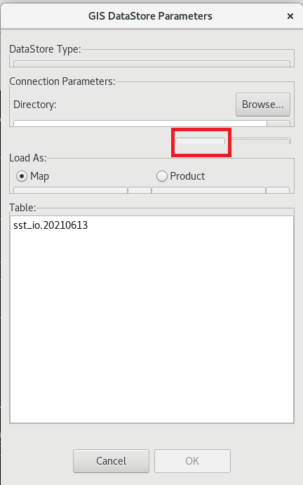
Hi Tom,

> Okay, I was able to go through and follow the procedure you outlined. I can
> see the files in
> the VM but they are all grayed out and I cannot select the shapefiles to
> load. What might be
> causing that?

Thank you very much for bringing this issue up actually.  I was able to run our
VM for CAVE v20
and the GIS import window looks really terrible for me.  I'm not sure if it
looks the same for
you?  Please see the attached photo to confirm.

It should like the photos shown in our blog post:
https://www.unidata.ucar.edu/blogs/news/entry/awips-tips-import-shapefiles-in

So, what you actually want to do (which is not intuitive), but outlined in that
blog, is to
"..to open a file chooser and navigate to the folder containing your
shapefile."  So, it is
perfectly okay that your shape files are showing up grayed out.  You'll want to
select the
folder they're in, and then normally you'd hit the "Connect" button (shown in
the blog).
I've highlighted this in red, from my VM screenshot.

Once you do that, the actual shapefile(s) should populate in the lower portion
of the dialog.

Please let me know if this helps?  And we'll definitely put this on the list of
things to
address.


--Shay Carter

She/Her/Hers
AWIPS Software Engineer
UCAR - Unidata

If you're interested, please feel free to fill out a survey about the support
you receive:
https://docs.google.com/forms/d/e/1FAIpQLSeDIkdk8qUMgq8ZdM4jhP-ubJPUOr-mJMQgxInwoAWoV5QcOw/viewform

Ticket Details
===================
Ticket ID: XCZ-543179
Department: Support AWIPS
Priority: Low
Status: Open
===================
NOTE: All email exchanges with Unidata User Support are recorded in the Unidata
inquiry tracking system and then made publicly available through the web.  If
you do not want to have your interactions made available in this way, you must
let us know in each email you send to us.
Attachment:
v20-vm-import-gis.png
Description: PNG image