


The Integrated Data Viewer (IDV) from Unidata is a Java™-based software framework for analyzing and visualizing geoscience data. This IDV release includes a software library and a reference application made from that software. It uses the VisAD (http://www.ssec.wisc.edu/~billh/visad.html) and netCDF-Java (https://www.unidata.ucar.edu/netcdf-java) libraries and other Java-based utility packages.
The IDV is developed at the Unidata Program Center (UPC), part of the University Corporation for Atmospheric Research (UCAR), Boulder, Colorado, which is funded by the National Science Foundation. The software is freely available under the terms of the GNU Lesser General Public License.
The IDV "reference application" is a geoscience display and analysis software system with many of the standard data displays that other Unidata software (e.g. GEMPAK and McIDAS) provide. It brings together the ability to display and work with satellite imagery, gridded data (for example, numerical weather prediction model output), surface observations, balloon soundings, NWS WSR-88D Level II and Level III RADAR data, and NOAA National Profiler Network data, all within a unified interface. It also provides 3-D views of the earth system and allows users to interactively slice, dice, and probe the data, creating cross-sections, profiles, animations and value read-outs of multi-dimensional data sets. The IDV can display any Earth-located data if it is provided in a known format (see Data Sources).
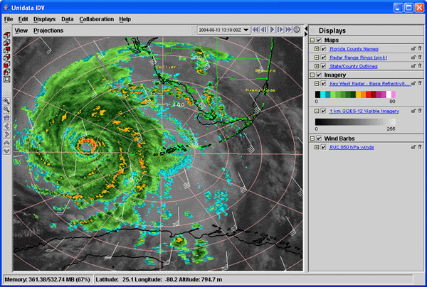
Image 1: IDV view of Hurricane Charlie, August 13, 2004
integrating satellite, radar, model and geopolitical data
The IDV software library can be easily be used and extended to create custom geoscience applications beyond the atmospheric science realm. This customization allows new applications to be tailored to specific datasets and provide customized user interfaces for different tasks. Examples of specialized IDV applications include the GEON IDV (https://geon.unavco.org/unavco/IDV_for_GEON.html) and McIDAS-V (https://www.ssec.wisc.edu/mcidas/software/v/).
Development of the IDV is ongoing at the Unidata Program Center. The development is driven by the needs of the community of users. Suggestions, comments, and collaboration are welcomed and encouraged. The goal is to provide new and innovative ways of displaying and analyzing Earth science data, as well as provide common displays that many users have come to expect.