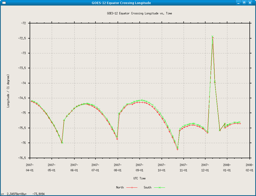
Hi Marek,

re:
> I have two questions, that I need to most recent update on:
> #
> 1. How far North, (or more general what is the geographic span in
> latitude/longitude of current GOES-11(W) iand GOES-12(E)?

The northern/southern most extent of any GOES scan is determined by the
scanning schedule which changes.  If you take into account that both GOES-East
and GOES-West perform full disk scans every three hours, then you would have to
say that the northern most extent is 90N and the southern most is 90S.  If
you are looking for the North/South extents of any particular scan, you will
have to calculate the value from the scan itself.  Again, the scanning is
more-or-less fixed, but it does change a bit.

> 2. What is the current exact geographic position of GOES-11
> and GOES-12?
> Can somebody provide me that info?

Geostationary satellites are, in fact, not located at a fixed longitude or
latitude...
GOES-12 drifts from east to west and is then moved back east by station keeping
maneuvers.
Likewise, GOES-11 drifts from west to east and is then moved back west by
station
keeping maneuvers.  Both satellites drift away from 0 latitude and are returned
to
0 latitude through station keeping maneuvers.

Station keeping maneuvers are made because NOAA operations is required to keep
its geostationary
satellites within a 1 degree box centered on their nominal (intended)
longitudnal locations. This
is so that geostationary satellites maintain a 2 degree separation in space.

The nominal location for GOES-11 is 135W longitude.  The nominal location for
GOES-12 is 75W
longitude.

NOAA posts the _forecast_ locations of GOES-10/11/12 on a NOAASIS website about
once per week:

http://noaasis.noaa.gov/cemscs/eqxngs.txt

We have been monitoring this site since setting up a GOES-10 ingest system at
the
end of January, 2007.  Over the course of now almost 12 months, we determined
that the locations being posted on the NOAASIS website were not necessarily
correct.
I had an interaction Chris Wheeler, the GOES Team Lead for NOAA, back on
November 28,
2007 about our observation that the values being reported were seemingly
inconsistent
with the requirement that geostationary satellites be kept within a one degree
box
centered on their nominal position.  The graph I have attached illustrates the
point
that we made to Chris -- the indicated longitudnal position of GOES-12 far
exceeded
the 1 degree box requirement.  Chris passed the word to appropriate people so
that
they could look into how the values that were being posted were generated.  They
apparently found some sort of a problem, since the values since the end of
November,
2007 have been much more in line with what they should be.

> Thanks,

No worries.


Cheers,

Tom
****************************************************************************
Unidata User Support                                    UCAR Unidata Program
(303) 497-8642                                                 P.O. Box 3000
address@hidden                                   Boulder, CO 80307
----------------------------------------------------------------------------
Unidata HomePage                       http://www.unidata.ucar.edu
****************************************************************************


Ticket Details
===================
Ticket ID: DZP-918446
Department: Support Datastream
Priority: Normal
Status: Closed
Attachment:
goes12longitude.png
Description: PNG image