


McIDAS can process images from geostationary and polar orbiting satellites. Geostationary satellites remain above a fixed location on the earth's surface, appoximately 22,236 mi above the equator. Because the satellites rotate with the earth, they always observe the same portion of the globe.
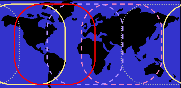
Currently, GOES-East observes North and South America and the western Atlantic Ocean. GOES-West monitors North America and the north and south portions of the eastern Pacific Ocean. EUMETSAT has two satellites (METEOSAT/MSG) which monitor Europe, Africa, western Asia and the eastern Atlantic Ocean. JMA has a satellite (GOES-Pacific/MTSAT) which monitors eastern Asia, Australia, the western Pacific Ocean and the eastern Indian Ocean. GOES-Pacific is a United States satellite that has been loaned to JMA after the failure of GMS. GOES-Pacific will monitor the areas GMS covered until MTSAT is launched.
The image below shows the coverage of each geostationary satellite:
Polar orbiting satellites orbit at much lower altitudes (800-900 km). Their path is 2,400 km wide centered at the orbit path. With each orbit, the satellites observe a new path. Currently, SSEC ingests a variety of POES satellites including: NOAA-12, NOAA-14, NOAA-15, NOAA-16, NOAA-17, Aqua, and Terra.
IMGLIST GV4.1 FORM=EXP
Image file directory listing for:GV4
 Pos Satellite/         Date       Time      Center      Res (km)   Image_Size
     sensor                                 Lat  Lon    Lat   Lon
 --- -------------  ------------  --------  ---- ----  ----- ----- ------------
   1 GOES-7        13 MAR 93072  17:01:00    26   87
    Band: 1   0.65 um Daytime cloud detection            4.0   4.0  1335 x 1608
     proj:    0 created: 1993208 191703  memo: AAA-MSI TO VIS      VIA ARCHIVE
     type:VISR     cal type:BRIT
     offsets:  data=  768 navigation=  256 calibration=    0 auxillary=    0
     doc length:   0   cal length:   0   lev length:   0 PREFIX=   4
     valcod: 1104210435 zcor:  1 avg-smp: A
     start yyddd: 1993072  start time:170105  start scan:   56
     lcor: 1121  ecor:  7585  bytes per pixel: 1  ss: 32
     Image Center Point Res (derived)  Lat:   4.37 (km)  Lon:   3.64 (km)
IMGLIST: done
In ADDE, sequences of AREA files are grouped together in a dataset. For example, in a previous lesson, you created the dataset MYDATA/IMAGES, which contains the AREA file numbers from 1 to 9999. Individual AREA files can be accessed with their position number within the dataset. In the case of MYDATA/IMAGES, position 3 (MYDATA/IMAGES.3) would relate to the file AREA0003. However, in the dataset MYDATA/TEST-IMAGES that was created in the previous lesson, the dataset defined the AREA files ranging from 4000 to 4004, so position 3 (MYDATA/TEST-IMAGES.3) would be AREA4002. (This would be equivalent to MYDATA/IMAGES.4002)
LINE = LCOR + (I-1) * LR
ELEMENT = ECOR + (J-1) * ER
The number of lines and elements extracted from the original image (LSIZ, ESIZ) determines the size of the image sector.
| Imagery Data type | AREA numbers | ADDE dataset names |
| GOES-East/West H2O Composite | 70-79 | RTIMAGES/GEW-WV |
| GOES-East/West IR Composite | 80-89 | RTIMAGES/GEW-IR |
| GOES-East/West VIS Composite | 90-99 | RTIMAGES/GEW-VIS |
| Mollweide Composite IR | 100-109 | RTIMAGES/MOLL-IR |
| Mollweide Composite H2O | 110-119 | RTIMAGES/MOLL-WV |
| GOES-West Western US VIS | 120-129 | RTIMAGES/GW-VIS |
| GOES-West Western US IR | 130-139 | RTIMAGES/GW-IR |
| GOES-East North America VIS | 140-149 | RTIMAGES/GE-VIS |
| GOES-East North America IR | 150-159 | RTIMAGES/GE-IR |
| GOES-West Western US H2O | 170-179 | RTIMAGES/GW-WV |
| Antarctic IR Composite | 190-199 | RTIMAGES/ANTARCTIC |
| Manually Digitized Radar | 200-209 | RTIMAGES/MDR |
| GOES-East North America H2O | 210-219 | RTIMAGES/GE-WV |
| GOES-East IR/TOPO Composite | 220-229 | RTIMAGES/GE-IRTOPO |
| GOES-East VIS/TOPO Composite | 230-239 | RTIMAGES/GE-VISTOPO |
| GOES-West IR/TOPO Composite | 240-249 | RTIMAGES/GW-IRTOPO |
| GOES-West VIS/TOPO Composite | 250-259 | RTIMAGES/GW-VISTOPO |
| MDR/TOPO Composite | 260-269 | RTIMAGES/MDRTOPO |
| Mollweide IR/TOPO Composite | 270-279 | RTIMAGES/MOLL-IRTOPO |
| GOES-East/West IR/TOPO Composite | 280-289 | RTIMAGES/GEW-IRTOPO |
| GOES-East/West VIS/TOPO Composite | 290-299 | RTIMAGES/GEW-VISTOPO |
| GOES-East/West VIS/TOPO Composite | 290-299 | RTIMAGES/GEW-VISTOPO |
| GOES-East North America 3.9 um IR | 1220-1229 | RTIMAGES/GE-39 |
| GOES-East North America 13.0 um IR | 1230-1239 | RTIMAGES/GE-CO2 |
| GOES-West North America 3.9 um IR | 1230-1239 | RTIMAGES/GW-39 |
| GOES-West North America 12.0 um IR | 1240-1249 | RTIMAGES/GW-12 |
| CIMSS Cloud Top Pressure product | 1100-1109 | CIMSS/CTP |
| CIMSS Precipitable Water product | 1110-1119 | CIMSS/PW |
| CIMSS Sea Sfc. Temperature product | 1120-1129 | CIMSS/SST |
| CIMSS Lifted Index product | 1130-1139 | CIMSS/LI |
| CIMSS CAPE product | 1140-1149 | CIMSS/CAPE |
| CIMSS Ozone product | 1150-1159 | CIMSS/OZONE |
| CIMSS Nth. Am. Wildfire ABBA product | 1190-1199 | CIMSS/FIRESNH |
| CIMSS Sth. Am. Wildfire ABBA product | 1200-1209 | CIMSS/FIRESSH |
Unidata has reserved AREA numbers 1-1999 and 9000-9999 for products in this and other IDD data streams. If you are going to change the default AREA numbers for products, you need to avoid these AREA number ranges. The table below lists the default AREA numbers that are used for topography images contained in the Unidata McIDAS distribution.
| Topography Imagery Distributed with Unidata McIDAS | |||
|---|---|---|---|
| Imagery Data type | AREA number | ADDE dataset names | |
| Global Mercator | 9000 | TOPO/GLOB | |
| North America - Mercator | 9010 | TOPO/MERC | |
| Western Hemisphere | 9012 | TOPO/WHEMI | |
| Southern Hemisphere | 9013 | TOPO/SPOLE | |
| Northern Hemisphere | 9014 | TOPO/NPOLE | |
| Global Mollweide | 9015 | TOPO/MOLL | |
| GOES-East Center at 75W | 9016 | TOPO/GOESE | |
| GOES-West Center at 135W | 9017 | TOPO/GOESW | |
| US Radar projection | 9018 | TOPO/MDR | |
| NW Quadrasphere | 9019 | TOPO/QUAD | |
Unidata sites can also subscribe to NNEXRAD or FNEXRAD IDD feeds to receive the full or floater sets, respectively, of NEXRAD Level III image products that are available in NOAAPORT. These products come in a zlib-compressed format that bears no relation to McIDAS AREA, but can still be served by McIDAS ADDE.
| NOAAPORT NEXRAD Level III NNEXRAD/FNEXRAD Imagery | |
|---|---|
| Imagery Data type | ADDE dataset names |
| NEXRAD Base Reflectivity Tilt 1 | RTNEXRAD/N0R |
| NEXRAD Base Reflectivity Tilt 2 | RTNEXRAD/N1R |
| NEXRAD Base Reflectivity Tilt 3 | RTNEXRAD/N2R |
| NEXRAD Base Reflectivity Tilt 4 | RTNEXRAD/N3R |
| NEXRAD Composite Reflectivity | RTNEXRAD/NCR |
| NEXRAD Layer Reflect SFC-24 K ft | RTNEXRAD/N0L |
| NEXRAD Layer Reflect 24-33 K ft | RTNEXRAD/N1L |
| NEXRAD Layer Reflect 33-60 K ft | RTNEXRAD/N2L |
| NEXRAD Echo Tops | RTNEXRAD/NET |
| NEXRAD Vertical Liquid H2O | RTNEXRAD/NVL |
| NEXRAD 1-hour Surface Rain Total | RTNEXRAD/N1P |
| NEXRAD 3-hour Surface Rain Total | RTNEXRAD/N3P |
| NEXRAD Storm Total Rainfall | RTNEXRAD/NTP |
| NEXRAD Radial Velocity Tilt 1 | RTNEXRAD/N0V |
| NEXRAD Radial Velocity Tilt 2 | RTNEXRAD/N1V |
| NEXRAD Radial Velocity Tilt 3 | RTNEXRAD/N2V |
| NEXRAD Radial Velocity Tilt 4 | RTNEXRAD/N3V |
| NEXRAD 248 nm Base Reflectivity | RTNEXRAD/N0Z |
| NEXRAD Storm-Rel Mean Vel Tilt 1 | RTNEXRAD/N0S |
| NEXRAD Storm-Rel Mean Vel Tilt 2 | RTNEXRAD/N1S |
| NEXRAD Storm-Rel Mean Vel Tilt 3 | RTNEXRAD/N2S |
Unidata sites can to the FNEXRAD IDD feed to receive the NEXRAD Level III product composites created by the UPC.
| NOAAPORT NEXRAD Level III FNEXRAD Composite Imagery | |
|---|---|
| Imagery Data type | ADDE dataset names |
| NEXRAD 1 km Base Reflectivity Tilt 1 | NEXRCOMP/1KN0R-NAT |
| NEXRAD 1 km Base Reflectivity Tilt 1 Floater | NEXRCOMP/1KN0R-FLT |
| NEXRAD 2 km 1-hour Surface Rain Total | NEXRCOMP/2KN1P-NAT |
| NEXRAD 4 km Storm Total Rainfall | NEXRCOMP/4KNTP-NAT |
| NEXRAD 6 km Base Reflectiveity Tilt 1 | NEXRCOMP/6KN0R-NAT |
| NEXRAD 10 km Radar Coded Message | NEXRCOMP/10KRCM-NAT |
Users with NOAAPORT satellite ingestion systems also have access to GINI imagery. What set of GINI images they may get will depend on which NOAAPORT channels they receive. Unidata McIDAS users also have access to the NOAAPORT GINI imagery through ADDE.
NOAAPORT Channel 1 GINI imagery.
| Imagery Data type | ADDE dataset names |
| 1 km VIS East CONUS | GINIEAST/GE1KVIS |
| 4 km 13.3 um East CONUS | GINIEAST/GE8KCO2 |
| 4 km 3.9 um East CONUS | GINIEAST/GE4K39 |
| 4 km 10.7 um East CONUS | GINIEAST/GE4KIR |
| 8 km WV East CONUS | GINIEAST/GE8KWV |
| 24 km 12.0 um Nhem-Composite | GINIEAST/GNC24K12 |
| 24 km 3.9 um Nhem-Composite | GINIEAST/GNC24K39 |
| 24 km 10.7 um Nhem-Composite | GINIEAST/GNC24KIR |
| 24 km VIS Nhem-Composite | GINIEAST/GNC24KVIS |
| 24 km WV Nhem-Composite | GINIEAST/GNC24KWV |
| 8 km 10.7 um Puerto Rico National | GINIEAST/GPN8KIR |
| 8 km VIS Puerto Rico National | GINIEAST/GPN8KVIS |
| 8 km WV Puerto Rico National | GINIEAST/GPN8KWV |
| 1 km VIS Puerto Rico Regional | GINIEAST/GPR1KVIS |
| 4 km 12.0 um Puerto Rico Regional | GINIEAST/GPR4K12 |
| 4 km 3.9 um Puerto Rico Regional | GINIEAST/GPR4K39 |
| 4 km 10.7 um Puerto Rico Regional | GINIEAST/GPR4KIR |
| 8 km WV Puerto Rico Regional | GINIEAST/GPR8KWV |
| 8 km 12.0 um Super-National | GINIEAST/GSN8K12 |
| 8 km 3.9 um Super-National | GINIEAST/GSN8K39 |
| 8 km Sounder Cloud Top Pressure | GINIEAST/GSN8KCTP |
| 8 km 10.7 um Super-National | GINIEAST/GSN8KIR |
| 8 km Sounder Lifted Index | GINIEAST/GSN8KLI |
| 8 km Sounder Precipitable Water | GINIEAST/GSN8KPW |
| 8 km Sounder SFC Skin Temperature | GINIEAST/GSN8KSFCT |
| 8 km VIS Super-National | GINIEAST/GSN8KVIS |
| 8 km WV Super-National | GINIEAST/GSN8KWV |
NOAAPORT Channel 2 GINI imagery.
| Imagery Data type | ADDE dataset names |
| 8 km 10.7 um Alaska National | GINIWEST/GAN8KIR |
| 8 km VIS Alaska National | GINIWEST/GAN8KVIS |
| 8 km WV Alaska National | GINIWEST/GAN8KWV |
| 16 km WV Alaska Regional | GINIWEST/GAR16KWV |
| 2 km VIS Alaska Regional | GINIWEST/GAR2KVIS |
| 8 km 12.0 um Alaska Regional | GINIWEST/GAR8K12 |
| 8 km 3.9 um Alaska Regional | GINIWEST/GAR8K39 |
| 8 km 10.7 um Alaska Regional | GINIWEST/GAR8KIR |
| 14 km IR Hawaii National | GINIWEST/GHN14KIR |
| 14 km VIS Hawaii National | GINIWEST/GHN14KVIS |
| 14 km WV Hawaii National | GINIWEST/GHN14KWV |
| 1 km VIS Hawaii Regional | GINIWEST/GHR1KVIS |
| 4 km 12.0 Hawaii Regional | GINIWEST/GHR4K12 |
| 4 km 3.9 um Hawaii Regional | GINIWEST/GHR4K39 |
| 4 km 10.7 um Hawaii Regional | GINIWEST/GHR4KIR |
| 8 km WV Hawaii Regional | GINIWEST/GHR8KWV |
| 24 km 10.7 um Mult-Composite | GINIWEST/GMC24KIR |
| 24 km VIS Mult-Composite | GINIWEST/GMC24KVIS |
| 24 km WV Mult-Composite | GINIWEST/GMC24KWV |
| 24 km 12.0 um Nhem-Composite | GINIWEST/GNC24K12 |
| 24 km 3.9 um Nhem-Composite | GINIWEST/GNC24K39 |
| 24 km 10.7 um Nhem-Composite | GINIWEST/GNC24KIR |
| 24 km VIS Nhem-Composite | GINIWEST/GNC24KVIS |
| 24 km WV Nhem-Composite | GINIWEST/GNC24KWV |
| 8 km 12.0 um Super-National | GINIWEST/GSN8K12 |
| 8 km 3.9 um Super-National | GINIWEST/GSN8K39 |
| 8 km Sounder Cloud Top Pressure | GINIWEST/GSN8KCTP |
| 8 km 10.7 um Super-National | GINIWEST/GSN8KIR |
| 8 km Sounder Lifted Index | GINIWEST/GSN8KLI |
| 8 km Sounder Precipitable Water | GINIWEST/GSN8KPW |
| 8 km Sounder SFC Skin Temperature | GINIWEST/GSN8KSFCT |
| 8 km VIS Super-National | GINIWEST/GSN8KVIS |
| 8 km WV Super-National | GINIWEST/GSN8KWV |
| 1 km VIS West CONUS | GINIWEST/GW1KVIS |
| 4 km 12.0 um West CONUS | GINIWEST/GW4K12 |
| 4 km 3.9 um West CONUS | GINIWEST/GW4K39 |
| 4 km 10.7 um West CONUS | GINIWEST/GW4KIR |
| 8 km WV West CONUS | GINIWEST/GW8KWV |
NOAAPORT Channel 1/2 GINI imagery.
| Imagery Data type | ADDE dataset names |
| 24 km 12.0 um Nhem-Composite | GINICOMP/GNC24K12 |
| 24 km 3.9 um Nhem-Composite | GINICOMP/GNC24K39 |
| 24 km 10.7 um Nhem-Composite | GINICOMP/GNC24KIR |
| 24 km VIS Nhem-Composite | GINICOMP/GNC24KVIS |
| 24 km WV Nhem-Composite | GINICOMP/GNC24KWV |
| 8 km 12.0 um Super-National | GINICOMP/GSN8K12 |
| 8 km 3.9 um Super-National | GINICOMP/GSN8K39 |
| 8 km 10.7 um Super-National | GINICOMP/GSN8KIR |
| 8 km VIS Super-National | GINICOMP/GSN8KVIS |
| 8 km WV Super-National | GINICOMP/GSN8KWV |
Unidata sites can also subscribe to WSI Corporation for NIDS and NOWrad® imagery in non-AREA format.
| Imagery Data type | ADDE dataset names |
| NIDS Base Reflectivity Tilt 1 | RTNIDS/BREF1 |
| NIDS Base Reflectivity Tilt 2 | RTNIDS/BREF2 |
| NIDS Base Reflectivity Tilt 3 | RTNIDS/BREF3 |
| NIDS Base Reflectivity Tilt 4 | RTNIDS/BREF4 |
| NIDS Composite Reflectivity | RTNIDS/CREF |
| NIDS Layer Reflect SFC-24 K ft | RTNIDS/LREF1 |
| NIDS Layer Reflect 24-33 K ft | RTNIDS/LREF2 |
| NIDS Layer Reflect 33-60 K ft | RTNIDS/LREF3 |
| NIDS Echo Tops | RTNIDS/TOPS |
| NIDS Vertical Liquid H2O | RTNIDS/VIL |
| NIDS 1-hour Surface Rain Total | RTNIDS/PRE1 |
| NIDS 3-hour Surface Rain Total | RTNIDS/PRE3 |
| NIDS Storm Total Rainfall | RTNIDS/PRET |
| NIDS Radial Velocity Tilt 1 | RTNIDS/RVEL1 |
| NIDS Radial Velocity Tilt 2 | RTNIDS/RVEL2 |
| NIDS Radial Velocity Tilt 3 | RTNIDS/RVEL3 |
| NIDS Radial Velocity Tilt 4 | RTNIDS/RVEL4 |
| NIDS 248 nm Base Reflectivity | RTNIDS/BRLR1 |
| NIDS Storm-Rel Mean Vel Tilt 1 | RTNIDS/SRMV1 |
| NIDS Storm-Rel Mean Vel Tilt 2 | RTNIDS/SRMV2 |
| NOWrad 2 km US Composite Reflectivity | RTNOWRAD/2KM |
| NOWrad 8 km US Composite Reflectivity | RTNOWRAD/8KM |
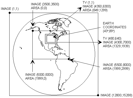
If a displayed image sector is navigated, McIDAS can convert the image coordinates of a specified pixel to earth coordinates. The E command lists the earth, TV and image coordinates at the cursor center.
| Satellite | Visible Image | Infrared |
| GOES | 1 km | 4 km |
| METEOSAT | 1 km | 3 km |
| GMS | 1.25 km | 5 km |
| POES | 1 km | 1 km |
You can display imagery at a resolution other than that stored in the area. Specifying a positive magnification factor in McIDAS commands (e.g., IMGDISP) enlarges or blows up the data by replicating pixel values; a negative magnification factor produces a blow down by sampling pixel values. For example, if you choose a magnification factor of 16, the value of each pixel in the area is duplicated 256 times (in a 16 x 16 box of pixels) when displayed on the frame. If you choose a magnification factor of -4, the value of every fourth element along every fourth line is displayed as one pixel on the image frame.