Hi,all
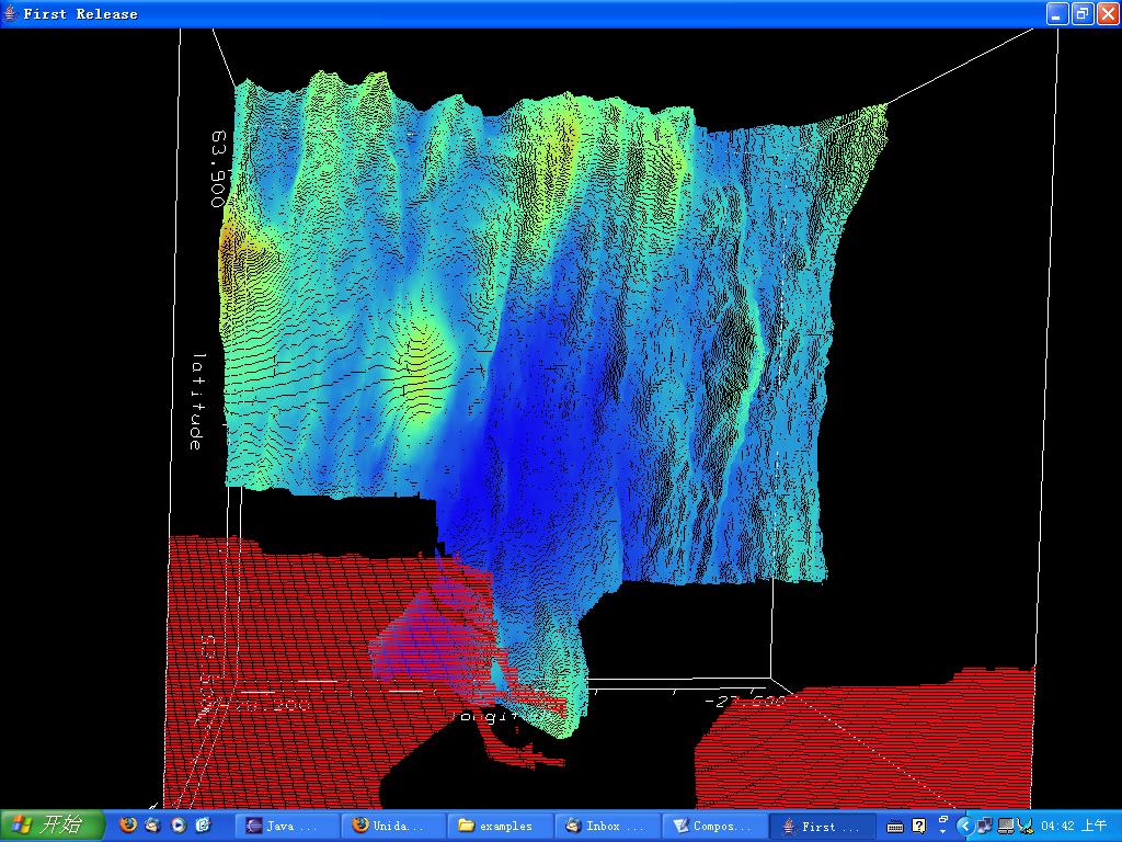
I have been using visAD for about 3 days, and I feel it is a best
visualization toolkit i have ever met. now I have a grid 2d data set,
and the mathtype is (latitude, longitude)-> depth, finally I got the
result like this:(see attachment)
as u see, they are lots of points, so how i can form a surface of the
terrain?
another question is I want to isosurface, I add
depthIsoMap = new ScalarMap( depth, Display.IsoContour );
display.addMap(depthMap);
ContourControl isoControl = (ContourControl) depthIsoMap.getControl();
isoControl.setContourFill(true);
isoControl.enableContours(true);
but i got the following exception:
java.lang.ArrayIndexOutOfBoundsException: -1
at visad.Contour2D.contour(Contour2D.java:355)
at visad.Gridded3DSet.makeIsoLines(Gridded3DSet.java:2068)
at visad.ShadowType.makeContour(ShadowType.java:3663)
at visad.java3d.ShadowTypeJ3D.makeContour(ShadowTypeJ3D.java:466)
at
visad.ShadowFunctionOrSetType.doTransform(ShadowFunctionOrSetType.java:2110)
at
visad.java3d.ShadowFunctionOrSetTypeJ3D.doTransform(ShadowFunctionOrSetTypeJ3D.java:100)
at
visad.java3d.DefaultRendererJ3D.doTransform(DefaultRendererJ3D.java:99)
at visad.java3d.RendererJ3D.doAction(RendererJ3D.java:181)
at visad.DisplayImpl.doAction(DisplayImpl.java:1691)
at visad.ActionImpl.run(ActionImpl.java:353)
at visad.util.ThreadPool$ThreadMinnow.run(ThreadPool.java:95)
the code are attached, thank you for your help in advance!!
best wishes
hao bo tang
department of Computer Science
university of Durham,uk
/*
 * Created on 2005-8-5
 *
 * TODO To change the template for this generated file go to
 * Window - Preferences - Java - Code Style - Code Templates
 */
package test;

import java.sql.Connection;
import java.sql.*;

/**
 * @author nakatayo
 *
 * TODO To change the template for this generated type comment go to
 * Window - Preferences - Java - Code Style - Code Templates
 */
public class accessDB {

          private Connection con = null;
          private Statement s = null;
          private ResultSet rs = null;

          public accessDB(){
          }

          public boolean openConnection() {
            boolean b = false;
            try {
              String userName = "root";
              String password = "alex";
              String url = "jdbc:mysql://127.0.0.1:3306/geo_data";
              Class.forName("com.mysql.jdbc.Driver").newInstance();
              con = DriverManager.getConnection(url,userName,password);
              System.out.println("Database connection established");
            }
            catch( SQLException ex ) {
                // handle any errors
                System.out.println("SQLException: " + ex.getMessage());
                System.out.println("SQLState: " + ex.getSQLState());
                System.out.println("VendorError: " + ex.getErrorCode());
                b = false;
            }
            catch (Exception e) {
              e.printStackTrace();
              b = false;
              System.err.println("Cannot connect to database server");
          }
          return b;
        }

          public double[] getLatitude() throws SQLException{

                double latitude = 0.0;
                double[] latitude_Data = new double[407173];

        try {
                ResultSet rs = null;
                int index = 0;
            if (s== null) s= con.createStatement();
            String sql = "SELECT latitude FROM geo_data1";
            s.executeQuery(sql);
            rs = s.getResultSet();
            while (rs.next()) {
                latitude = rs.getDouble("latitude");
                latitude_Data[index]= latitude;
                index++;
            }
            System.out.print(latitude_Data.length);
        } catch (Exception ex) {
            ex.printStackTrace();
            System.err.println ("Error message: " + ex.getMessage ());
        }
                return latitude_Data;
          }

          public double[] getlongitude() throws SQLException{

                double longitude = 0.0;
                double[] longitude_Data = new double[407173];
                ResultSet rs = null;
        try {
                int index = 0;
            if (s== null) s= con.createStatement();
            String sql = "SELECT longitude FROM geo_data1";
            s.executeQuery(sql);
            rs = s.getResultSet();
            while (rs.next()) {
                longitude = rs.getDouble("longitude");
                longitude_Data[index]= longitude;
                index++;
            }
            System.out.print(longitude_Data.length);
        } catch (Exception ex) {
            ex.printStackTrace();
            System.err.println ("Error message: " + ex.getMessage ());
        }
                return longitude_Data;
          }

          public double[] getdepth() throws SQLException{

                double depth = 0.0;
                double[] depth_Data = new double[407173];
                ResultSet rs = null;
        try {
                int index = 0;
            if (s== null) s= con.createStatement();
            String sql = "SELECT depth FROM geo_data1";
            s.executeQuery(sql);
            rs = s.getResultSet();
            while (rs.next()) {
                depth = rs.getDouble("depth");
                depth_Data[index]= depth;
                index++;
            }
            System.out.print(depth_Data.length);
        } catch (Exception ex) {
            ex.printStackTrace();
            System.err.println ("Error message: " + ex.getMessage ());
        }
                return depth_Data;
          }

        public void closeDB() throws SQLException {
        s.close();
        con.close();
    }

        public static void main(String[] args) {
        }
}
package test;

/*
VisAD Tutorial
Copyright (C) 2000 Ugo Taddei
*/

// Import needed classes

import visad.*;
import visad.java2d.DisplayImplJ2D;
import java.rmi.RemoteException;
import java.sql.SQLException;
import java.awt.*;
import javax.swing.*;
import java.awt.event.*;
import visad.java3d.DisplayImplJ3D;
import visad.util.ContourWidget;

  /*

  Note:

    - alternative use of a Linear2DSet
    - common heightNaN values "interpolates" domain set -> weird!
    - call GraphicsModeControl.setPolygonMode(1); to draw mesh

 */


public class DGM1{

    // Declare variables
    // The domain quantities longitude and latitude
    // and the dependent quantities altitude, temperature

    private RealType latitude,longitude;
    private RealType depth;

    // Two Tuples: one to pack longitude and latitude together, as the domain
    // and the other for the range (altitude, temperature)
    private RealTupleType domain_tuple;

    // The function (domain_tuple -> range_tuple )
    private FunctionType func_en_h;

    // Our Data values for the domain are represented by the Set
    private Set domain_set;

    // The Data class FlatField
    private FlatField vals_ff;

    // The DataReference from data to display
    private DataReferenceImpl data_ref;

    // The 2D display, and its the maps
    private DisplayImpl display;
    private ScalarMap latMap, lonMap, depthMap,depthIsoMap;


    private ContourWidget contourWid;


    public DGM1(String []args) throws RemoteException, VisADException,
SQLException {

    accessDB db = new accessDB();
    db.openConnection();
        double[] latNaN = db.getLatitude();
        double[] lonNaN = db.getlongitude();
        double[] depthNaN = db.getdepth();
        db.closeDB();

        //System.out.println(latNaN.length);
        //System.out.println(lonNaN.length);
        //System.out.println(depthNaN.length);

        //for (int i=0; i<latNaN.length;i++){

        //      System.out.println(latNaN[i]);
        //}

        //for (int i=0; i<latNaN.length;i++){

                //System.out.println(lonNaN[i]);
        //}

        int nCols = latNaN.length;
        int nRows = 1;
        double[][] coords = new double[2][latNaN.length];
        for (int i=0;i<(nCols*nRows);i++) {
            coords[0][i]=latNaN[i];
            coords[1][i]=lonNaN[i];
        }


        // Create the quantities
        // Use RealType(String name);
        latitude = new RealType("latitude",SI.meter,null);
        longitude = new RealType("longitude",SI.meter,null);

        domain_tuple = new RealTupleType(latitude,longitude);

        depth = new RealType("depth",SI.meter,null);

        // Create a FunctionType (domain_tuple -> range_tuple )
        // Use FunctionType(MathType domain, MathType range)
        func_en_h = new FunctionType(domain_tuple, depth);


  // UT
        domain_set = new Gridded2DDoubleSet(domain_tuple,coords,nRows,nCols);
    //domain_set = new Linear2DSet(domain_tuple,1,5,5,1,9,9);

        // Get the Set samples to facilitate the calculations
        float[][] set_samples = domain_set.getSamples( true );


        // We create another array, with the same number of elements of
        // altitude and temperature, but organized as
        double[][] flat_samples = new double[1][nCols*nRows];

        // ...and then we fill our 'flat' array with the generated values
        // by looping over NCOLS and NROWS
        // specifiy height

        for(int c = 0; c < nCols; c++)

            for(int r = 0; r < nRows; r++)

                     flat_samples[0][ c * nRows + r ] = depthNaN[c*nRows+r];;
                //flat_samples[0][ c * nRows + r ]= c*nRows+r;

        /*
        int index = 0;

        for(int c = 0; c < 2; c++)
          for(int r = 0; r < nRows*nCols; r++){

            // set altitude
            flat_samples[0][ index ] = set_samples[c][r];

            // increment index
            index++;
          }
          */
            /*
        for(int c = 0; c < nCols; c++){
            for(int r = 0; r < nCols; r++){
        // UT
                 flat_samples[0][c*nRows+r] = c*nRows+r;
       //flat_samples[0][c*nRows+r] = heightNaN[c*nRows+r];
       //System.out.println("height "+heightNaN[c*nRows+r]);
       //System.out.println("height " + flat_samples[c*nRows+r]);
            }
        }
        */
        /*
        for(int c = 0; c < NCOLS; c++)
            for(int r = 0; r < NROWS; r++){
                flat_samples[0][c*NROWS+r] = heightNaN[c*NROWS+r];

                //System.out.println("height "+height[c*NROWS+r]);
            }
        */


    // Get the funtionc from the FlatField for slope


        // Create a FlatField
        // Use FlatField(FunctionType type, Set domain_set)
        vals_ff = new FlatField( func_en_h, domain_set);

        // ...and put the values above into it
        // Note the argument false, meaning that the array won't be copied
        vals_ff.setSamples( flat_samples , false );

    // Create a ScalarMap to color slope's surface

        // Create Display and its maps
        // A 2D display
        display = new DisplayImplJ3D("display1");

        // Create the ScalarMaps: latitude to XAxis, longitude to YAxis and
        // altitude to RGB and temperature to IsoContour
        // Use ScalarMap(ScalarType scalar, DisplayRealType display_scalar)
        latMap = new ScalarMap( latitude,    Display.YAxis );
        lonMap = new ScalarMap( longitude, Display.XAxis );
        depthMap = new ScalarMap(depth,Display.ZAxis);
        depthIsoMap = new ScalarMap( depth,  Display.IsoContour );

        // Add maps to display
        display.addMap( latMap );
        display.addMap( lonMap );
        display.addMap(depthMap);

  // UT
  //display.addMap( heightMap );

  // UT
    display.addMap( new ScalarMap(depth,Display.RGB) );
    display.addMap(depthIsoMap);

    latMap.setRange(63.5, 63.9333);
        lonMap.setRange(-28.2333,-27.5833);
        depthMap.setRange(-5000.0,0);

        //latMap.setRange(60,70);
        //lonMap.setRange(27,29);
        //depthMap.setRange(0,5000);
        //heightMap.setRange(200,300);
        //heightMap.setRange(-1.0,1.0);

        // Create a data reference and set the FlatField as our data
        data_ref = new DataReferenceImpl("data_ref");
        data_ref.setData( vals_ff );

        display.addReference(data_ref);

           //ContourControl isoControl = (ContourControl)
depthIsoMap.getControl();
           // isoControl.setContourInterval(interval, lowValue, highValue,
base);
           //isoControl.setContourFill(true);
           //isoControl.enableContours(true);

  // UT
  GraphicsModeControl dispGMC = (GraphicsModeControl)
   display.getGraphicsModeControl();
  dispGMC.setScaleEnable(true);
  dispGMC.setTextureEnable(true);
  dispGMC.setPointMode(true);
  dispGMC.setPointSize(1.0f);
  //dispGMC.setPolygonMode(1);


        // Create application window and add display to window
        JFrame jframe = new JFrame("First Release");
        jframe.getContentPane().add(display.getComponent());

        // Set window size and make it visible
        jframe.setSize(300, 300);
        jframe.setVisible(true);
    }


    public static void main(String[] args)
        throws RemoteException, VisADException, SQLException
    {
        new DGM1(args);
    }

} //end of Visad Tutorial Program 3_09